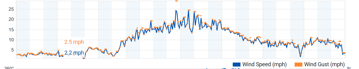
¡Buenos dias! The wind gauge trace at Rasta Beach yesterday looked more like a seismograph during a major earthquake (see graph below) as a pronounced west component produced very inconsistent and gusty winds there. The gauge at the campground also showed a persistent west component with average 10 minute sustained winds in the 16-18 mph range with gusts well into the mid 20s. An Oceansat satellite pass just after midnight showed NW winds at 15 knots near Cerralvo, but the latest batch of model forecasts indicate that the background NW flow will gradually become more northerly this afternoon, and although northern beaches may still see gusty conditions at times, we should see better quality wind today. Surface high pressure centered over the 4-corners region of the U.S. early this morning will merge with a ridge of high pressure over the eastern Pacific on Sunday, creating an elongated ridge of high pressure extending from the Eastern Pacific to the northern Baja Peninsula and countinuing northeastward into Arizona. Model forecasts are in good agreement that this feature will remain nearly stationary through Thursday, with ample north background flow continuing for our region. Although some thin, high clouds will likely stream overhead from time to time this week, we should see enough sun each day to trigger our local thermal. Long-range model forecasts are in excellent agreement that a strong surface high just west of California will build eastward into the interior west of the U.S. on Friday and begin to tighten the surface pressure gradient over BCS with increasing north flow here.
- Today…Sunny. North wind 18-22 mph.
- Sunday…Mostly sunny. North wind 18-22 mph.
- Monday…Mostly sunny. North wind 16-20 mph.
- Tuesday…Sunny. North wind 18-22 mph.
- Wednesday…Mostly sunny. North wind 18-22 mph.
- Thursday…Mostly sunny. North wind 16-20 mph.
- Friday…Mostly sunny. North wind 18-22 mph.