La Ventana Stories, an ongoing series of write-ups, started in December 2018, about the history and the happenings of La Ventana Bay and the surrounding region. Contributed by seasonally resident authors, look for a new story every few weeks during the windy season.
La Ventana Stories
Kissing Bugs
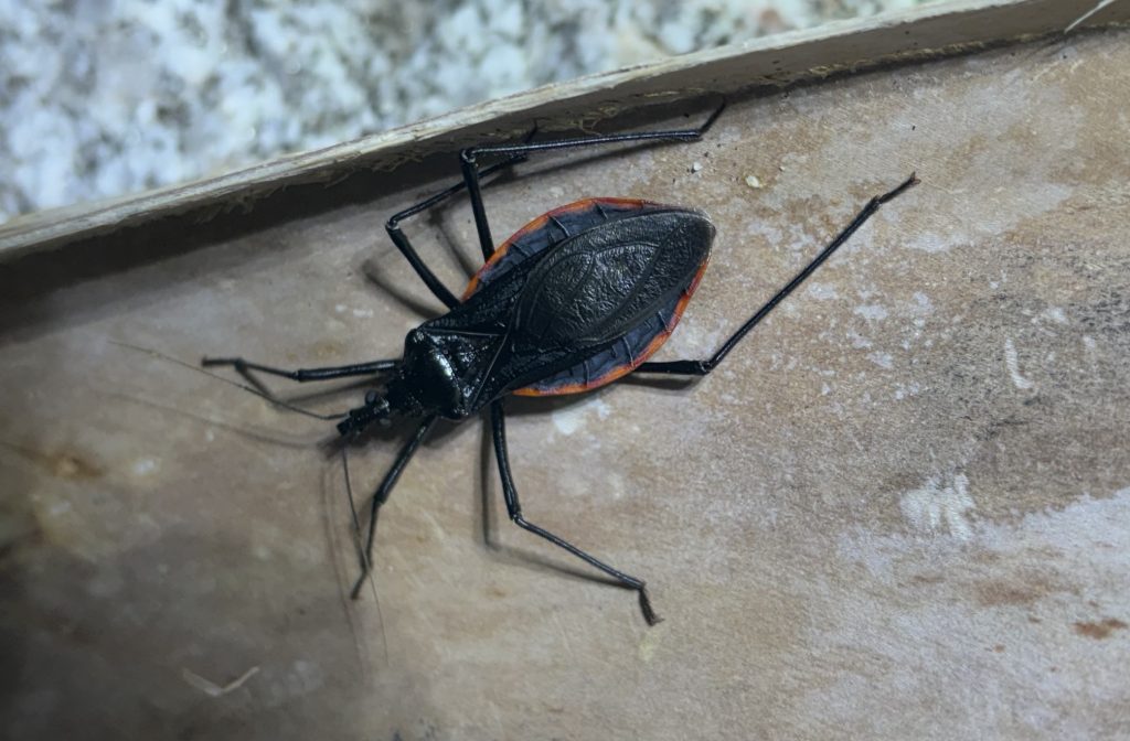
Today I am not writing about reptiles because I believe this subject is important. Here in La Ventana/El Sargento, we are at around 24 degrees latitude, and this means we are very close to the tropics. We are lucky, for the most part, that there aren’t too many dangerous creatures in our area. Most of us are familiar with Black Widows and rattlesnakes, but there is one local dangerous insect that many people do not know about, and that is the Kissing Bug.
Kissing bugs are large, blood-sucking insects inhabiting much of Central America. Our local species, Dipetalogaster maxima, is not all that common, but I have seen individuals just outside of town. They are relatively easy to identify, as they are quite large.
The reason these insects are dangerous is because they transmit a disease called Chagas. The disease is not transmitted when they bite, but rather when they poop on you, which is basically whenever they bite. Chagas disease can be deadly. Learn more about it at the CDC.
Luckily, Kissing Bugs are nocturnal and like to inhabit rocky arroyos, so they are not often encountered. They only really feed at night so, as long as you are sleeping in a tent, you should have nothing to fear.
The moral of this story is: Never sleep outside without a tent in Southern Baja.
If you want to read more reptile-related stories, please subscribe to my Substack page, Beneath The Scales, where I write more in-depth about my favorite topic.
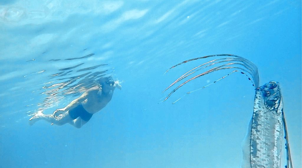
Swimming with Oarfish
For those of you that missed my previous post, Swimming with Oarfish, a video I made earlier this summer, here it is again. This is my second Oarfish rescue encounter taking place this past May of 2024, on the very same beach where the video Oarfish Rescue was filmed just two years before, almost to the day.
Oarfish are truly amazing deep water filter feeders living in waters between 600-3000 feet deep. Why they get beached no one knows for sure, but in this video, Swimming with Oarfish, after observing the behavior of this fish, I take a shot at a hypothesis.
If you see a beached Oarfish, if it’s stilll alive and kicking, you can help it into the water. But do so carefully, because, although they can grow up to 36 feet, they are delicate creatures with sensitive skin and an easily breakable dorsal fin that they can’t swim without. Stay tuned, my next video post, How to Rescue an Oarfish, will provide tips on how to save an Oarfish without doing harm.
If you spot a beached Oarfish, note the time and location, please contact me. I’m launching the Oarfish Beaching Awareness Project to gather data on beached Oarfish around La Ventana Bay- reported by local residents. That way we can track the location, time and frequency of these beachings and learn a little more about this fish.
If someone has a color printer and wouldn’t mind hanging a few posters about this project around town, please let me know. Thank you. Contact William at desertplayer@hotmail.com
Rain and Toads
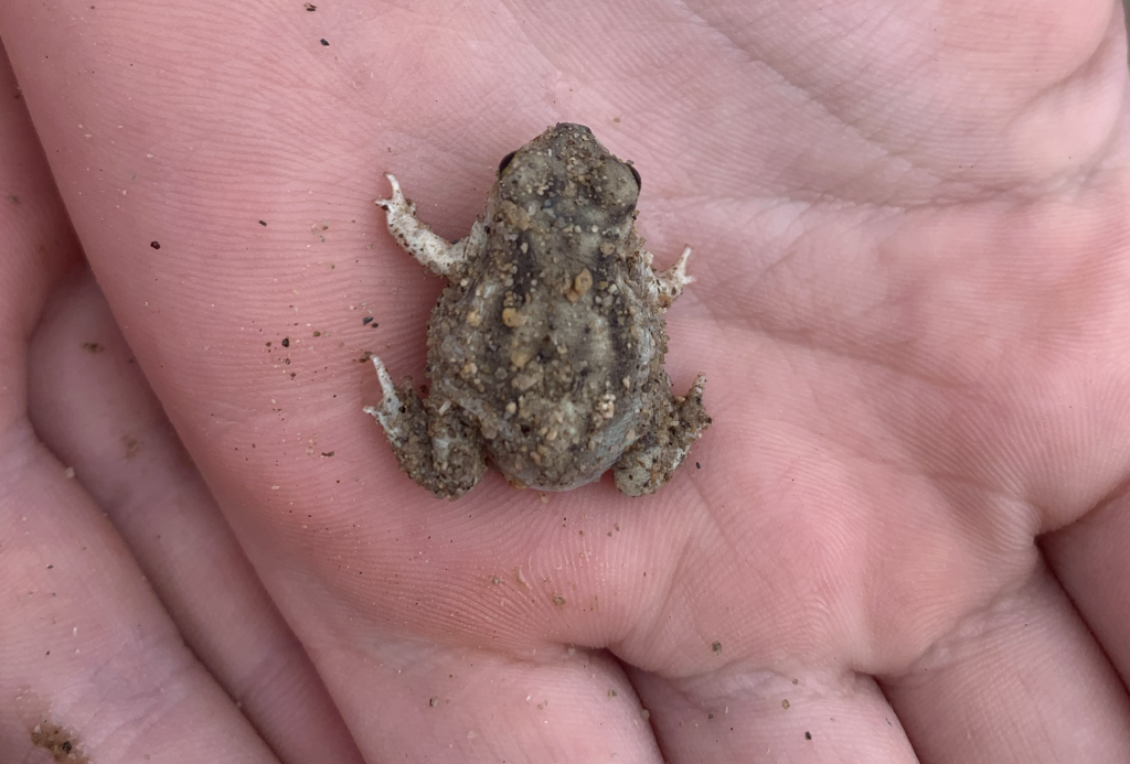
I returned back to El Sargento from the United States on the 12th of September, just in time to catch the first big rain event of the year: Tropical Storm Ileana. I had been watching this storm form on radar, trying to figure out how to pronounce “Ileana.” I knew the area had not received much rain yet this year, and I was very excited at the prospect of a rainy arrival to Baja. When I arrived — the day before the storm — as I exited the terminal at San Jose del Cabo, I smacked into a wall of heat and humidity. Though I momentarily questioned my decision to return to the hot and humid desert, the idea of rain kept my spirits high.
I love rain events in Baja because Couch’s Spadefoot Toads — somewhat unexpected residents of the driest state in North America — erupt from the ground to breed. Historically, after a big rain, a toad pond has appeared in our neighbors’ driveway; due to construction, unfortunately, this one-week-wonder pond no longer fills. So I have been working on a replacement pond. The morning of the storm, I heard raindrops on my roof at around 5am. Iliana was now officially a tropical storm. As soon as the sun rose, I was outside. The first six hours or so were a bit anticlimactic because all we experienced was a steady drizzle, followed by the rain stopping all together. It had not rained enough to fill a toad pond.
However, there were plenty of toads! Big ones, little ones, green ones and round ones. I even found a male calling in a little puddle. In the desert, standing water doesn’t last long, so these “toads” have one of the quickest breeding cycles of all frogs. I say “toads” because spadefoots aren’t actually toads; they are their own kind of frog that has evolved a very similar body plan. But anyway, these spadefoots will lay eggs, and the eggs will hatch within 48 hours! Then the tadpoles have a race to grow legs before the puddle dries up. They can transform from tadpole to frog in a little as seven days, although it is often a bit longer.
Hopefully we will have a bigger rain later this year, but it is not unusual that spadefoots will go years without having a chance to breed. Sometimes they only come up out of the ground once a year, or less if there is no rain. They often bury themselves up to a meter underground!
After the rain ended, I checked all the local cattle guards for stuck creatures. I found and helped many trapped frogs. Unfortunately, stuck creatures are real problem in La Ventana. Cattle guards may be useful pieces of infrastructure, but we need to stop making them with big concrete traps at the bottom. If you are going to build a cattle guard, please try to make an escape route for small creatures. One of the best ways to provide an easy way out is to leave slanted edges, or even just dirt, on either or both ends of the trench so creatures can escape.
Fall Reptile Walks! I am going to start this WhatsApp group for reptile walks, to make things a bit easier, and help account for uncertain weather conditions. Join the group here.
Machete of La Ventana Bay!
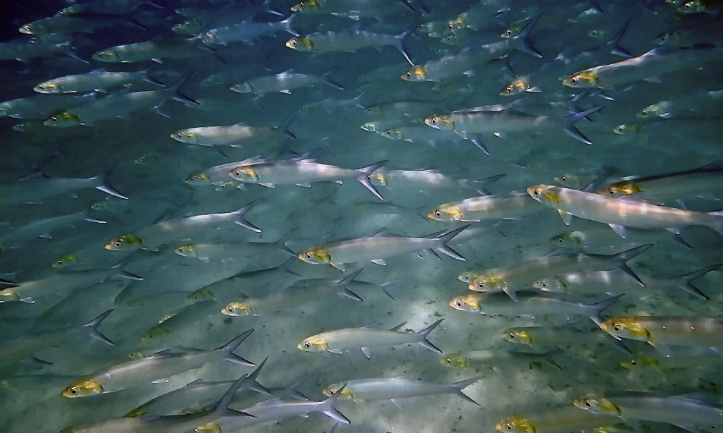
In 2019, while snorkeling along the shoreline of La Ventana Bay, I encountered, the largest school of Machete (Ladyfish) I have ever seen. When the Machete swam passed, they were a great wall of fish. I wanted to capture them as that wall of fish; all going the same direction. Finally, after four mornings of chasing them around, I got the shot I was after. Here is that unedited footage to celebrate this amazing school of fish that once lived along the La Ventana Bay shoreline. Machete of La Ventana Bay!
Espíritu Santo Striped Whipsnake
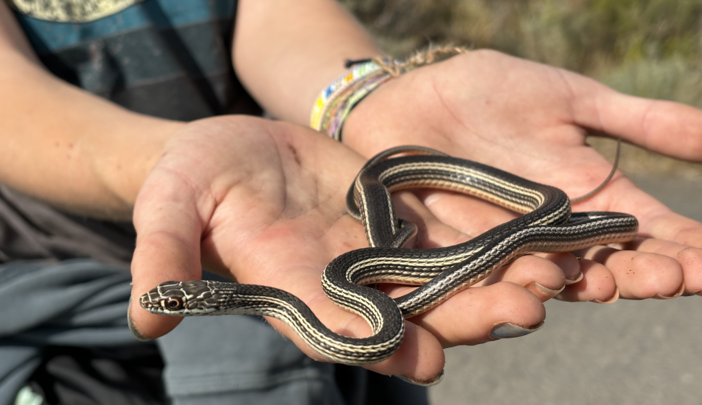
Isla Espíritu Santo is an incredible island off the coast of La Paz. It is home to many interesting creatures, including two endemic species of reptiles: the Espíritu Santo Whiptail (Aspidoscelis espiritensis) and the Espíritu Santo Striped Whipsnake (Masticophis barbouri). I have never been to the island, but I have received multiple trips as gifts that all managed to fall through one way or another. I will get there eventually, and hopefully find the interesting, beautiful and endemic whipsnake.
Whipsnakes are some of my favorite snakes. The group includes coachwhips, like our Baja California Coachwhips, the big black snakes often seen zooming across roads in La Ventana and El Sargento.
Some other members of the whipsnake family are the Striped Whipsnakes. I have seen several, though I haven’t really got a good look at one because they are very rare in Baja. If you do manage to find one, all you will see is an explosion of hypersonic dust; it makes matters worse that they like to live in between boulders.
If you would like to hear more about my quest to catch one of these lightning bolts, check out my new Substack newsletter: Beneath the Scales. There, I dive deeper into my adventures in search of rare and elusive creatures.
Isla Espíritu Santo is home to some cool land animals, but the unbelievable sea life is the real showstopper. Some years ago, the waters around the island were home to thousands and thousands of hammerhead sharks and an amazing diversity of fish. Life was beyond imagination and it was known as the world’s aquarium. Then, in just a few years, almost all of the hammerheads were fished for shark fin soup, and now the beautiful diversity is gone. I am no fish expert —that is William’s department— however, this seems important.
The good news is that the ecosystem can recover in just a few years if we stop fishing the reefs. This will not only bring scuba tourism back to the area, but the fish will overflow out of the preserve and bring more fish for people as well. Isla Espíritu Santo is a national park but only 4% is protected. Right now, there is an active petition aiming to turn Espíritu Santo’s waters into a reserve, which could quickly become as rich as Cabo Pulmo.
Help to bring life back! Learn More at Pelagios Kakunjá. Sign the petition here.
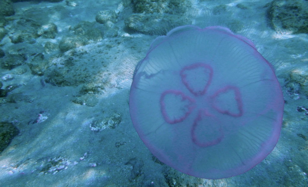
August with Moon Jellyfish and Mantas
Two things to report. One having to do with the return of the Moon Jellyfish, and the other, swimming with, Giant Manta Rays! This summer, we saw the return of the Moon Jellyfish to the La Ventana Bayshoreline. Last year, there were few, but last month, while snorkeling, had to navigate some tight clusters here and there, nothing like 2022! Here’s a video of the invasion of 2022: Moon Jelly Invasion! Here’s a short video close-up of cute little fish being housed safely within the bell of this Moon Jellyfish, filmed last month: Little Fish Inside the Jelly Bell!
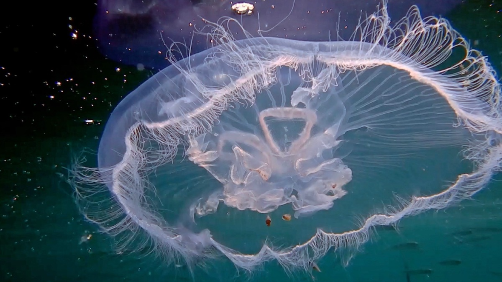
Moon Jellyfish are colorful and relatively harmless. They have very short tentacles. Luckily, their stings aren’t too serious, more like rubbing up against nettles. Watching them swim is a beautiful sight! Below, see the signature four-leaf clover design, that makes them easy to identify.
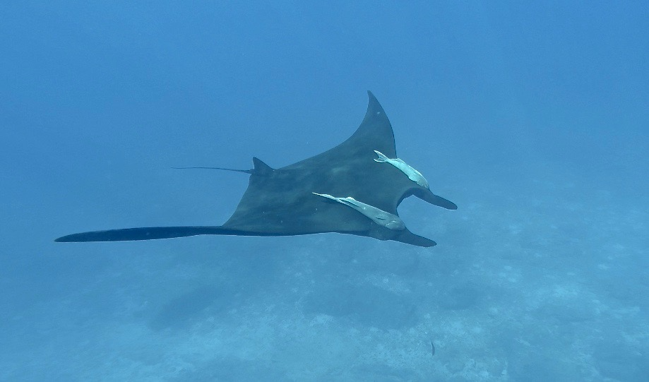
Swimming with Giant Manta Rays! On August 27, I traveled with a guide (Omar) and four friends to swim with the Giant Manta Rays. We departed from El Sargento at 7am traveling a good distance. Seeing these creatures for the first time was truly amazing. They appear to swim in slow motion, so peaceful looking. Here, a short clip of the Mantas swimming if you are interested: Swimming with Giant Mantas!
Damselfish of La Ventana Bay
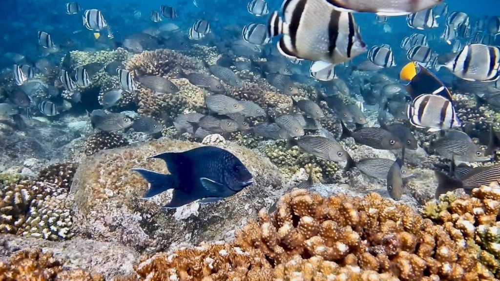
There are 250 types of Damselfish in the world, and I have run into six while snorkeling that I will share. This includes a fish that I visited over a five-year period, a Giant Damselfish. This fish species has a well defined small territory, allowing you to visit one over time, as I have done. In this video, Damselfish of La Ventana Bay there’s repeated photos of this fish, each dated. There is also a scene showing close-ups of nesting behavior, and how they change shades of blue for purposes I can only guess are for reproduction, but don’t know fully. To learn more about the ecology of our bay shoreline, visit: Observing Baja Coral Reef Fish or contact me, William, at desertplayer@hotmail.com
King Snakes
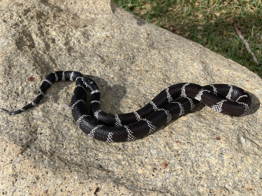
Kingsnakes are beautiful snakes. They are not easy to find in Baja but, when discovered, these striking snakes can have quite an effect. In Southern Baja, we have one species: the California Kingsnake (Lampropeltis californiae). This species has quite a large range, inhabiting many different habitats from Cabo to Oregon. Often they will be black with white bands but they can also be black with white stripes down their bodies.
Kingsnakes are loved by many people— even by those who dislike snakes — and it’s not because of their personality. Charming though they may be, Kingsnakes are famous rattlesnake eaters. Yet Kingsnakes also eat other snakes, rodents, lizards, amphibians and birds; they are true generalists, willing to eat whatever comes their way.
Because of their beautiful colors and hardy nature, Kingsnakes are often kept as pets. This is a bit of a problem because they are frequently taken out of the wild for the pet trade.
Kingsnakes are very secretive. It can be difficult to find them, even in places where they are common, unless you can find a window into their favorite habitat: the subterranean world. By flipping things over (like rocks, wood boards and especially sheet metal), Kingsnakes and many other snakes can be discovered. If you do this, however, make sure to carefully put their roof back just the way you found it to preserve their habitat.
Some people mistakenly believe Kingsnakes to be venomous, but they are not. Instead, they are very powerful constrictors for their size. In some places, Kingsnakes mimic venomous coral snakes, looking almost identical, but there are no coral snakes in Baja except for a small area near the California border. So don’t worry about any colorful little snakes in La Ventana because they are all harmless.
Some Rattlesnake Facts
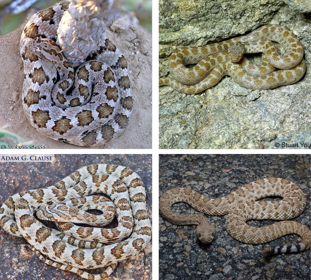
This time of year many snakes are out, including rattlesnakes. I get a lot of questions about our local rattlesnakes and hear rumors about them, many of which are false, so here are a few facts about these beautiful and important snakes.
In La Ventana/El Sargento, we have three species of rattlers: the Red Diamond Rattlesnake (Crotalus ruber), the Speckled Rattlesnake (Crotalus mitchellii) and the Baja California Rattlesnake (Crotalus enyo). All of these species have rattles and are dangerously venomous and should be given space. As for which are the most venomous, I do not really have an answer. I would treat all rattlesnakes with equal respect.
The rattle-less rattlesnakes that I hear people talking nervously about are only found on Isla Santa Catalina; none of them live on mainland Baja. Occasionally, rattlesnakes will lose their rattles, but this is quite rare.
There are other ways of identifying rattlesnakes besides their rattles. Their heads are quite large and their eyes have vertical pupils, but so do the eyes of many non-venomous snakes. Most rattlesnakes have black and white colored bands on their tails before the rattles, and are quite heavily built, meaning they are relatively short and fat.
One thing I hear often is that baby rattlesnakes are more dangerous than adults because they don’t know how to control their venom. I believe this to be completely false. Even if baby rattlesnakes used all of their venom in one bite, which is very unlikely, they still have much less venom than adults, because their venom glands are smaller. Baby rattlesnakes are definitely dangerous, I just would not say that they are any more dangerous than adults.
One last thing to note: rattlesnakes are venomous, not poisonous. Venom is injected into the bloodstream, whereas poison is eaten or touched.
If there are any questions about our venomous neighbors, I would love to answer them! Please email me anytime. Here are a few pictures of rattlesnakes next to pictures of harmless snakes. Can you tell the difference? Photo credits thanks to Adam Clause, Jackson Shedd, and Stuart Young. California Herps https://www.californiaherps.com/
Snakes on the Road
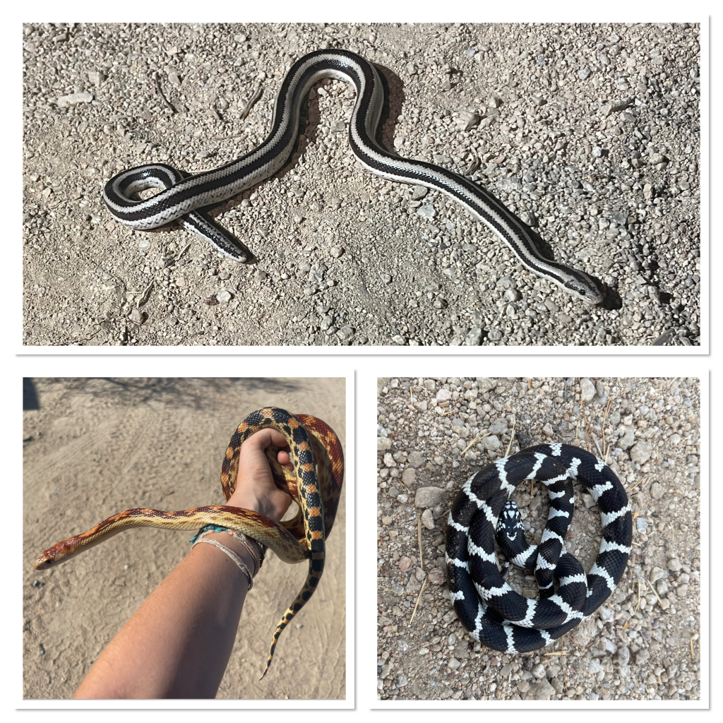
In the last few weeks, many reptiles have been out. April is probably the snakiest month of the year, as it is mating season. This time of year, snakes will leave their usual range and wander in search of other snakes, and food. Unfortunately, this means snakes are crossing roads much more than usual, which is very dangerous for them. Especially on the main roads, people drive fast, and many snakes move slowly. This spring I have seen more dead snakes than alive, and this truly breaks my heart.
Some snakes, like Coachwhips, move very fast, and can cross roads relatively safely. But others, like our beautiful and endemic Cape Gopher Snakes, and Rosy Boas, are very vulnerable. What I have noticed is that most of the snakes being hit are harmless species. I hope people do not run snakes over on purpose, but I know that they are often misconstrued as evil or dangerous, so I am afraid it is more common than I would like to know.
Accidental hits are unavoidable, but we can definitely reduce the number. If you see a live snake in the road, just stop the car in front of the snake and wait until the snake has crossed the road. This way you don’t even need to get out of your car, and the snake will make it across the road in one piece. If you help a snake in this way, or just see one, please try to take a picture, and I would love to identify it for you! I am starting a project studying which species of snake are found in La Ventana and El Sargento proper, compared to the surrounding desert, and every photo helps!