¡Buenos dias! The forecast for today is a low-confidence one, as several factors will be in play that could make or break it. First, a surface low pressure system just offshore of the far northern Baja Peninsula will move eastward today spreading rain as far south as far northern BCS. As the low approaches, it will nudge a narrow ridge of high pressure located just to our north farther southward, and this will likely add a significant west component to the background flow by midday. As the low then continues eastward this afternoon, several of the models show the ridge of high pressure moving back northward and our background flow becoming more favorable (northerly) by mid afternoon. The second big variable today wil be cloud cover. Models show increasing high clouds this morning, possibly thick enough to put a significant dent in our local thermal. A couple of the models do show some thin spots in the high cloud cover this afternoon, and if this does come to pass we could get rideable winds later this afternoon. Cloud cover will again be the main variable for tomorrow, as several models show the northern edge of a band of thick high clouds will be very near us. For now I’ll be optimistic and hope we see some afternoon sun. The latest model forecasts are in excellent agreement that a strong surface high pressure system will build into the interior west of the U.S. on Friday into Saturday and bring classic norte conditions to our region (see nerd note below). As well as the typical strong, gusty winds of a norte, wave models are predicting large swell by Friday afternoon, with the swell likely peaking on Saturday. Long-range model forecasts are in excellent agreement as well, with the strong surface high parked over the western U.S. and only slowly weakening into the middle of next week.
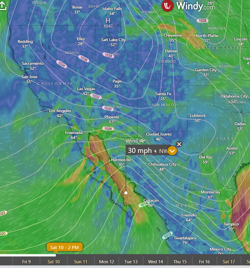
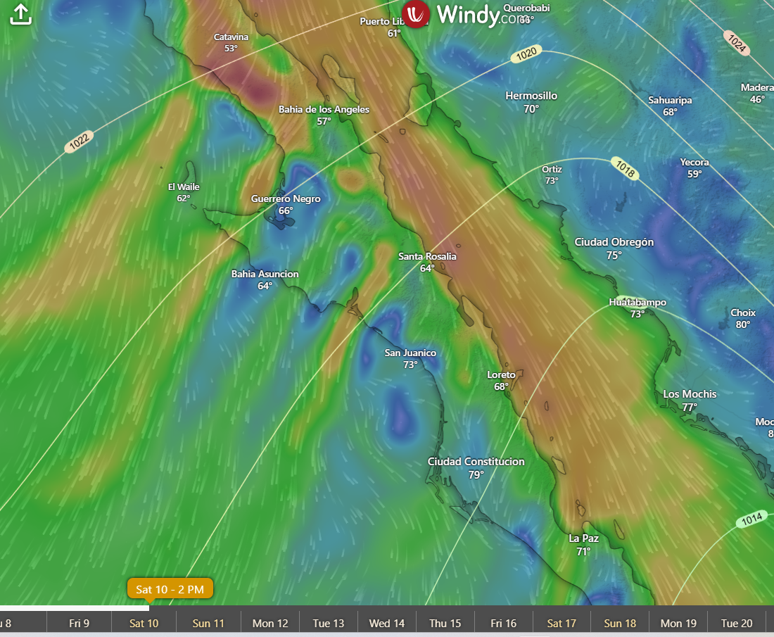
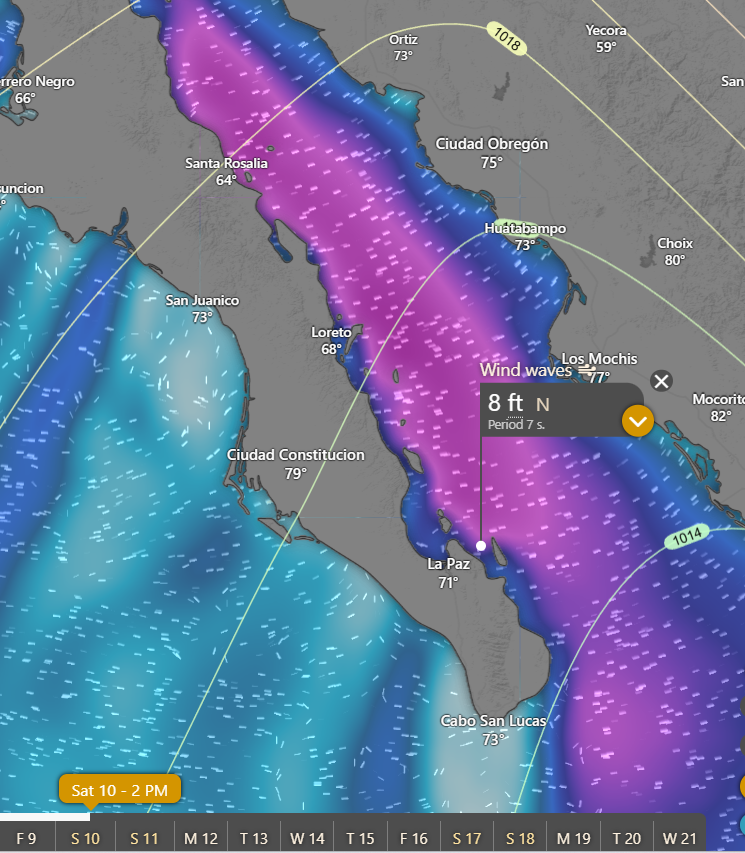
Nerd Note: While we really haven’t seen a big norte yet this season, the model forecasts for Friday and Saturday are showing the classic setup for a big one. The graphic below shows the forecast for surface pressure and wind speed for Saturday. Note the strong surface high centered over northern Utah with the tightly spaced isobars over the Baja Peninsula. The second graphic is zoomed in over the Baja Peninsula. Note the NNE to SSW bands of high winds as the strong flow is pushed through the relatively narrow mountain passes over the peninsula. The third graphic is the ECMWF forecast for wind swell on Saturday. At this point the model is forecasting open ocean swell height of 8 feet coming into the bay between Cerralvo and the Cacachilas mountains.
- Today…Increasing high clouds. North…northwest wind 16-18 mph possibly becoming north late.
- Thursday…Partly sunny. North wind 16-18 mph.
- Friday…Sunny. North wind 22-26 mph and gusty.
- Saturday…Mostly sunny. North wind 22-26 mph.
- Sunday…Sunny. North wind 20-24 mph.
- Monday…Mostly sunny. North wind 20-24 mph.
- Tuesday…Partly sunny. North wind 18-22 mph.