¡Buenos dias! No satellite-derived winds were available this morning, but all of the most recent model forecasts show ample NNW background flow will continue today. As was the case yesterday, cloud cover will be the controlling factor on wind speeds (see nerd note below). Infrared satellite loops early this morning showed a large area of mid-level clouds to our southwest was slowly moving northeastward, and model forecasts are in good agreement that we will see signficant cloud cover this afternoon. Of course if we see unexpected breaks in the clouds this afternoon, wind speeds will be higher than I’ve forecast. Models are in excellent agreement that full sunshine will return on Wednesday, and with sufficient NNW background flow also forecast, we will likely see a good thermal boost. Surface low pressure will begin to form over the southwestern U.S. on Thursday and substantially weaken the surface pressure gradient over BCS. At this point it looks like the background flow will fall below what we normally need to fully activate our wind machine. As the low moves slowly eastward from southern California on Friday into western New Mexico by late Saturday, our winds will remain light. Moisture circulating around the low will be drawn over BCS as the low passes to our north, and models are in good agreement that we will likely see some showers late Friday into Saturday, with anywhere from 0.25 to 0.5 inches of rain possible. As the low continues eastward on Sunday, surface high pressure will build into the interior west of the U.S. and the surface pressure gradient over BCS will tighten. Skies will also clear as drier air moves into our region, and with full sunshine expected on Sunday, we will likely see a windy afternoon. Long-range model forecasts are in good agreement that solid north background flow will then continue well into next week.
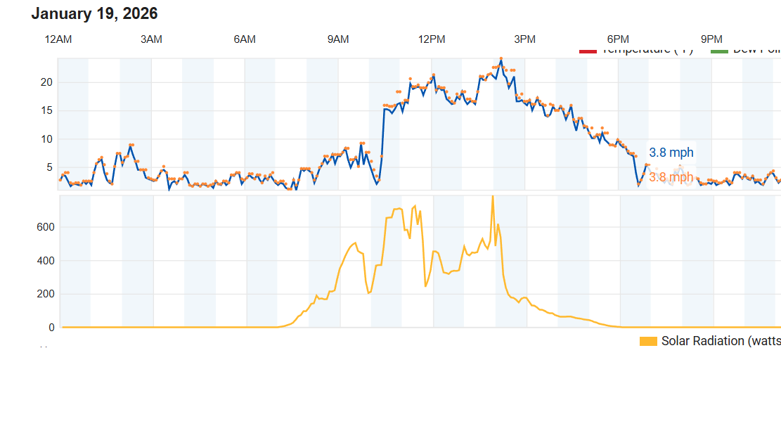
Nerd Note: Yesterday was a good example of how cloud cover can impact our local thermal. The graphic below show the wind speed and the solar radiation (amount of sunshine) measured at Rasta Beach yesterday. Note how the two graphs roughly mimic each other (with some time delay), with an early peak of winds from around 10:30 am until around noon, then winds decreased after clouds thickened around 11:45 am. As the cloud cover thinned a bit after 1 pm, wind speeds increased starting around 1:30 pm and peaked shortly after 2 pm. As clouds thickened again after around 2:15 pm, winds responded…weakening substantially by around 2:45 pm.
- Today…Partly sunny. North wind 14-16 mph.
- Wednesday…Sunny. North wind 16-20 mph.
- Thursday…Mostly sunny. North wind 12-14 mph.
- Friday…Mostly cloudy with a few showers possible late. Northeast wind 8-10 mph.
- Saturday…Mostly cloudy with showers likely. Light and variable wind.
- Sunday…Sunny. North wind 18-22 mph.
- Monday…Sunny. North wind 20-24 mph.