¡Buenos dias! Wind gauges at both Rasta Beach and the campground yesterday showed 10-minute average sustained winds peaked at around 20 mph (corrected for a 3-5 mph high bias in the Weather Underground platform) with gusts well into the mid 20s. There was a significant west component to the winds at Rasta, and the wind trace showed gusty conditions there…see nerd note below. An ASCAT satellite pass just before midnight measured 15-20 knot NNW winds near Cerralvo. The latest batch of model forecasts show the background flow decreasing a bit this afternoon, but ample north…northwest wind should persist through the day. As we discussed yesterday, the biggest variable this week will be the thickness of high cloud cover, and today is no exception. Infrared satellite loops early this morning showed thick high clouds over our region, but model forecasts are in good agreement that we will see at least some thinning of the high clouds this afternoon, with at least a partial thermal boost looking likely. Surface high pressure centered over western Colorado this morning will remain over the interior west of the U.S. for much of this week, with solid N to NNW background flow continuing through at least Friday. The surface high will begin to weaken on Saturday, then models are in good agreement that we’ll see the surface pressure gradient over BCS become very weak on Sunday into Monday, with only light onshore breezes expected then. We will continue a game of cat and mouse with the high clouds through Saturday, and I’ll likely have to tweek the wind speeds each day as we get a better picture of the short-term cloud cover…stay tuned.
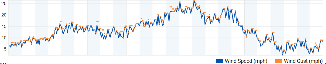
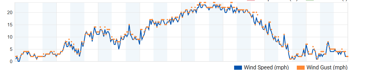
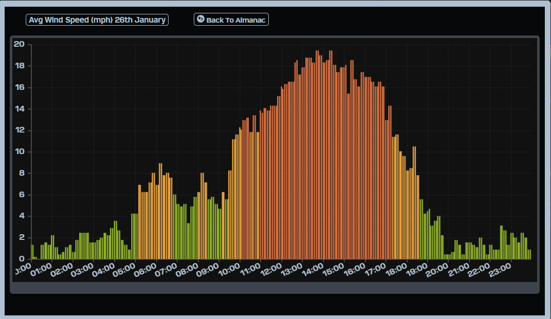
Nerd Note: Verification of wind forecasts can be subjective, so I stick to one method. To verify the forecasts each day, I use a wind gauge at the campground and a display platform that uses the world standard of 10-minute sustained winds. I also look at wind traces from the company Weather Underground, which displays 5-minute sustained winds and gusts at multiple locations. The graphs below show the Weather Underground wind speeds yesterday at Rasta (top graph), the Weather Underground wind speeds at the campground (middle graph), and the wind speeds using the campground gauge but with a 10-minute average wind speed (bottom graph). Note the high bias of 3-4 mph in the Weather Underground campground trace versus the 10-minute average trace for the same location. I’ve noticed over the last several years that this is a very consistent feature. Also, note how the Weather Underground trace at Rasta yesterday was very jagged compared to the camground, indicating gustier conditions up north.
- Today…Morning high clouds…then becoming partly sunny. North wind 16-20 mph.
- Wednesday…Partly sunny. North wind 16-20 mph.
- Thursday…Partly sunny. North wind 16-20 mph.
- Friday…Partly sunny. North wind 18-22 mph.
- Saturday…Partly sunny. North wind 16-18 mph.
- Sunday…Sunny. Northeast wind 10-12 mph.
- Monday…Sunny. Northeast wind 10-12 mph.