Wind – November, 2025

¡Buenos dias! An Oceansat satellite pass just after midnight measured W to NW winds of 5-10 knots north and east of Cerralvo. Surface analysis showed a relatively weak high pressure system centered over the 4-corners region of the U.S. this morning, and model forecasts show this feature will remain nearly stationary through Saturday. Although the location of the surface high is favorable for substantial north flow over BCS, the weakness of this feature in model forecasts will likely produce only marginal background north flow today through Saturday, and confidence is low that we’ll see enough to fully trigger our local wind machine. That said, sunny to mostly sunny skies could energize our local thermal just enough to bring rideable conditions so best to be ready just in case. Model forecasts are in good agreement that a ridge of high pressure will build into the central Baja Peninsula on Sunday and may give a boost to the north background flow here. Long-range model forecasts generally agree that the ridge of high pressure to our north will then migrate southward over BCS on Monday into Tuesday, with our winds become more westerly.

  • Today…Sunny. North wind 14-16 mph.
  • Thursday…Sunny. North wind 12-14 mph.
  • Friday…Sunny. North wind 14-16 mph.
  • Saturday…Mostly sunny. North wind 12-14 mph.
  • Sunday…Sunny. North wind 16-18 mph.
  • Monday…Sunny. Northwest wind 8-10 mph.
  • Tuesday…Mostly sunny. Northwest wind 8-10 mph.
Wind – November 11, 2025

¡Buenos dias! An evening pass by one of the ASCAT satellites measured west winds at around 5 knots just to the east of Cerralvo, and all of the latest numerical model forecasts show light background flow continuing for today. A relatively weak surface pressure gradient will remain over BCS for the next several days, with generally light winds. There is some indication that we may see a very slight bump in the background flow on Wednesday and Friday, but confidence is low. A weak surface low pressure system is forecast to move slowly across southern California and Arizona Friday into Saturday, and at this point it looks like light winds will continue through Saturday. A noticable change in the weather should occur Saturday night into Sunday as much cooler air will finally move into BCS (see nerd note below). As that happens, a narrow ridge of high pressure is forecast to build to our north with background north flow increasing on Sunday. The north pulse may be short-lived, with light winds returning next Monday.

Today…Sunny. Northeast wind 10-12 mph.
Wednesday…Sunny. North wind 14-16 mph.
Thursday…Sunny. North wind 12-14 mph.
Friday…Sunny. North wind 14-16 mph.
Saturday…Mostly sunny. East wind 8-10 mph.
Sunday…Sunny. North wind 16-20 mph.
Monday…Sunny. Northwest wind 8-10 mph.

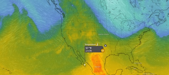
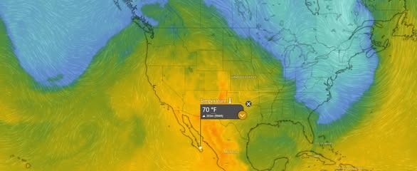
Nerd Note: As I mentioned several days ago, long-range global models have been forecasting a major shift in the middle and upper level weather pattern, with much cooler air forecast to finally move into BCS around the middle of November. These forecasts have held, and we should see a noticable cool down here Saturday night into Sunday. The graphics below show the air temperature at around 5000 ft today, with abnormally warm air over much of the western U.S. and Baja Peninsula as a persistent ridge of high pressure remains in place. Notice the trough off the west coast of the U.S., with much cooler air shown in blue. Fast-forward to Sunday and the trough has moved eastward over the Baja Peninsula and temperatures aloft have dropped substantially.

Wind – November 10, 2025

¡Buenos dias! An Oceansat satelllite pass just before midnight measured widespread 15 knot NW winds over the Sea of Cortez east of Cerralvo. While all of the latest model forecasts show the background flow will decrease today, there will still be ample north flow to combine with full sunshine and bring us another windy afternoon. Surface high pressure anchored to our north will weaken further on Tuesday, and only marginal north flow is forecast for our region Tuesday through Thursday. It’ll be close each day…stay tuned. Surface low pressure is then forecast to track across the southwestern U.S. and into northeastern Mexico Friday into Saturday, and circulation around this system will bring us northwest to west background flow. As the low continues eastward on Sunday, long-range forecasts show a return of north flow to BCS.

  • Today…Sunny. North wind 16-20 mph.
  • Tuesday…Sunny. North wind 14-16 mph.
  • Wednesday…Sunny. North wind 12-14 mph.
  • Thursday…Sunny. North wind 14-16 mph.
  • Friday…Sunny. Northwest wind 10-12 mph.
  • Saturday…Sunny. West wind 12-14 mph.
  • Sunday…Sunny. North wind 16-20 mph.

Wind – November 9, 2025

¡Buenos dias! An Oceansat satelllite pass just after midnight measured 10 knot NW winds over the Sea of Cortez east of Cerralvo. Model forecasts are in excellent agreement that surface high pressure centered near Salt Lake City this morning will build slowly southward today, with the surface pressure gradient tightening over BCS. As a result, north background flow will increase substantially, and with sunny skies expected, our local thermal will give an added boost. Ample north flow will continue on Monday, with our afternoon thermal giving us another windy afternoon. The surface pressure gradient will become weak on Tuesday, and at this point it looks like the resulting north background flow will fall to just below what normally triggers our wind machine. A couple of model forecasts show a small increase in the background flow on Wednesday and Thursday, but it’ll be close. Long-range forecasts are in good agreement that surface low pressure will track across the southwestern U.S. Friday into Saturday with westerly flow developing across BCS.

  • Today…Sunny. North wind 18-22 mph.
  • Monday…Sunny. North wind 16-20 mph.
  • Tuesday…Sunny. North wind 12-14 mph.
  • Wednesday…Sunny. North wind 14-16 mph.
  • Thursday…Sunny. North wind 16-18 mph.
  • Friday…Sunny. Northwest wind 10-12 mph.
  • Saturday…Sunny. West wind 12-14 mph.

Wind – November 8, 2025

¡Buenos dias! The wind gauge at Rasta yesterday showed a very slow climb from around 1 pm until around 2:30 when it reached a steady 12-14 mph for around an hour, giving several of us a nice foil session. We will likely see a similar day today, as model forecasts show the background north flow teetering right on the edge of what is normally needed to fully trigger our local wind machine. In situations like this we usually see the best chances for rideable winds on the north beaches. Sunday will see a significant increase in north background flow as models are in good agreement that an expansive surface high pressure system will build southward from Canada into much of the U.S. Monday will likely see a continuation of solid north flow and with another sunny day expected, our local thermal should be in fine form. The surface pressure gradient is then forecast to weaken rapidly on Tuesday, leaving us with only marginal north flow at best. Models are then hinting at a slight increase in winds for Wednesday and Thursday and with continued sunny days expected, we could see rideable conditions. Long-range model forecasts are in good agreement that Friday will likely see only light onshore breezes.

  • Today…Sunny. North wind 14-16 mph, lighter south beaches.
  • Sunday…Sunny. North wind 18-22 mph.
  • Monday…Sunny. North wind 16-20 mph.
  • Tuesday…Sunny. North wind 12-14 mph.
  • Wednesday…Sunny. North wind 14-16 mph.
  • Thursday…Sunny. North wind 16-18 mph.
  • Friday…Sunny. East wind 10-12 mph.

Wind – November 7, 2025

¡Buenos dias! Well…that was weird. The wind gauge at the campground showed winds climbed steadily through the morning and reached an early peak of 17 mph with gusts to 25 mph around noon, then the wind began a slow decline to around 14 mph at 1:30 pm…right about when the thermal should have been peaking. A late-morning satellite pass measured solid 15 knot NNW background flow around 10:30 am, and a satellite pass around midnight measured ample NW background flow of 10-15 knots just east of Cerralvo, so it’ll remain a mystery (at least to me). Model forecasts are in good agreement that the background flow today will fall to very near the lower limit that usually is needed to fully trigger our local wind machine. I’ll be optimistic since a couple of the more reliable models do show just enough to get at least a partial thermal response this afternoon. Very similar conditions are forecast for Saturday, so it’ll be another day to be ready just in case. Models are in good agreement that a ridge of high pressure will build over the Great Basin of the U.S. on Sunday and send a new surge of north flow into BCS. Surface high pressure is then forecast to remain in place near the 4-corners region of the U.S. on Monday, then slowly weaken Tuesday into Wednesday. For now, it looks like there will still be just enough north background flow on Tuesday and Wednesday to combine with abundant sunshine and continue the windy streak. At this point a couple of the long-range models indicate that Thursday will be marginal…stay tuned.

  • Today…Sunny. North wind 14-16 mph.
  • Saturday…Sunny. North wind 14-16 mph.
  • Sunday…Sunny. North wind 18-22 mph.
  • Monday…Sunny. North wind 16-20 mph.
  • Tuesday…Sunny. North wind 16-18 mph.
  • Wednesday…Sunny. North wind 16-18 mph.
  • Thursday…Sunny. North wind 14-16 mph.

Wind – November 6, 2025

¡Buenos dias! An Oceansat satellite pass around midnight measured solid 15 knot NW winds over the southern Sea of Cortez, and model forecasts show 10-15 knot NW background flow will continue today. A few thin, high clouds will stream overhead this morning, but we should see ample sunshine this afternoon and a good thermal boost. Yesterday saw gusty, holey conditions at the northern beaches as the winds retained a bit of westerly component and we saw some wind-shadowing. While the wind quality should be a bit better today, some gusty conditions are still possible, particularly on northern beaches. Models are in good agreement that the surface pressure gradient will weaken substantially on Friday, with the background flow falling to just below what would normally fully jump-start our local wind machine. Saturday looks similar, with maybe just a bit more background north flow. Models are in excellent agreement that a ridge of high pressure over the interior west of the U.S. will bring a new pulse of north background flow to BCS on Sunday. At this point the long-range model forecasts are in good agreement that surface high pressure will set up over the 4-corners region of the U.S. on Monday and last through much of next week, with steady north background flow and sunny skies each day bringing a great stretch of warm, windy afternoons.

  • Today…Mostly sunny. North wind 18-22 mph.
  • Friday…Sunny. North wind 12-14 mph.
  • Saturday…Sunny. Northeast wind 14-16 mph.
  • Sunday…Sunny. North wind 18-22 mph.
  • Monday…Sunny. North wind 16-20 mph.
  • Tuesday…Sunny. North wind 16-20 mph.
  • Wednesday…Sunny. North wind 16-20 mph.

Wind – November 5, 2025

¡Buenos dias! Yesterday a few folks got a late afternoon bonus as the gauge at the campground showed winds of 12-14 mph from 3-5:30 pm. More of us should be getting into the game today as a late-evening pass by one of the ASCAT satellites measured solid 10 knot NW winds over the southern Sea of Cortez, and all of the latest model forecasts indicated similar background wind will continue today. A few thin, high clouds will stream overhead from time to time today, but enough filtered sunshine will likely make it through to give us an added thermal bump this afternoon. The surface pressure gradient is forecast to tighten tomorrow as Pacific high pressure continues to build into the Baja Peninsula and with sunny skies expected, we should see a windy afternoon. Models are in good agreement that the background flow will become marginal on Friday, with winds decreasing further on Saturday. Long-range model forecasts are in good agreement that a strong Canadian surface high pressure system will dive into the central U.S. on Sunday, with a ridge of high presssue extending westward into the Great Basin. This will likely give a renewed boost to our north flow, with sufficient north background flow likely lasting through next Tuesday.

  • Today…Mostly sunny. North wind 16-20 mph.
  • Thursday…Sunny. North wind 18-22 mph.
  • Friday…Sunny. North wind 12-14 mph.
  • Saturday…Sunny. Northeast wind 10-12 mph.
  • Sunday…Sunny. North wind 16-20 mph.
  • Monday…Sunny. North wind 16-18 mph.
  • Tuesday…Mostly sunny. North wind 16-18 mph.

Wind – November 4, 2025

¡Buenos dias! Yesterday was one of those days where northern beaches saw winds peaking around 16 mph, while southern beaches only hovered around 12 mph. It looks like light winds will be the rule at all area beaches today, as a late evening pass by the Oceansat satellite measured light and variable winds across the southern Sea of Cortez, and all of the most recent numerical model forecasts show light background flow continuing today. Surface high pressure over the eastern Pacific will strengthen and build eastward into the Baja Peninsula on Wednesday, and this will bring increasing NW flow to BCS. While model forecasts do show some west component to the background wind, sunny skies should help trigger a substantial local thermal to help pull the flow onshore. Winds may increase a bit on Thursday, and with only a few thin, high clouds expected, we should see another good thermal boost as well. Friday looks to be a marginal day at this point as models generally agree that the surface pressure gradient will weaken substantially over our area. Long-range model forecasts are in fairly good agreement that some north flow will return on Sunday and last at least through next Monday.

  • Today…Sunny. Northeast wind 10-12 mph.
  • Wednesday…Sunny. North wind 16-20 mph.
  • Thursday…Mostly sunny. North wind 18-22 mph.
  • Friday…Sunny. North wind 12-14 mph.
  • Saturday…Sunny. Northeast wind 10-12 mph.
  • Sunday…Sunny. North wind 16-20 mph.
  • Monday…Sunny. North wind 16-18 mph.

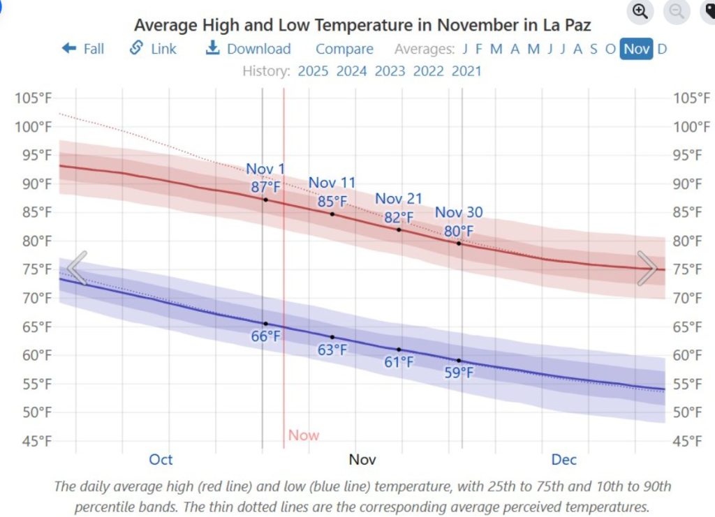
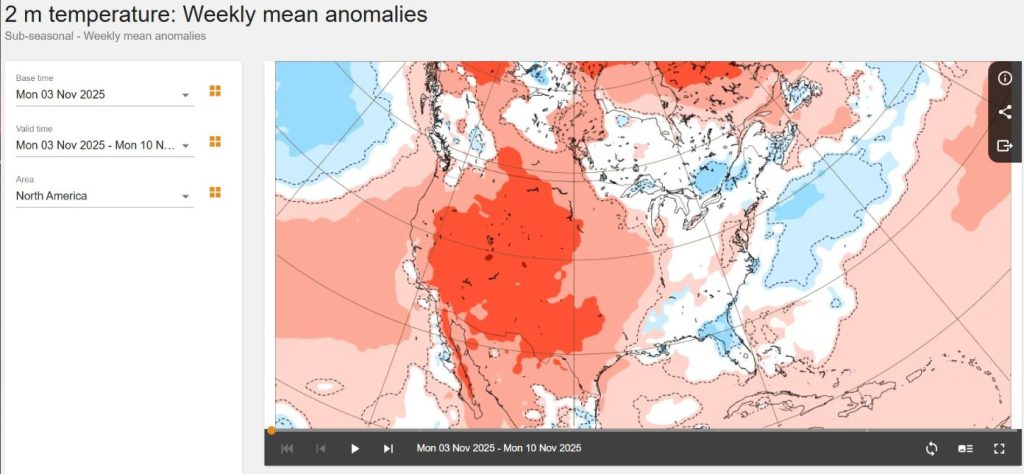
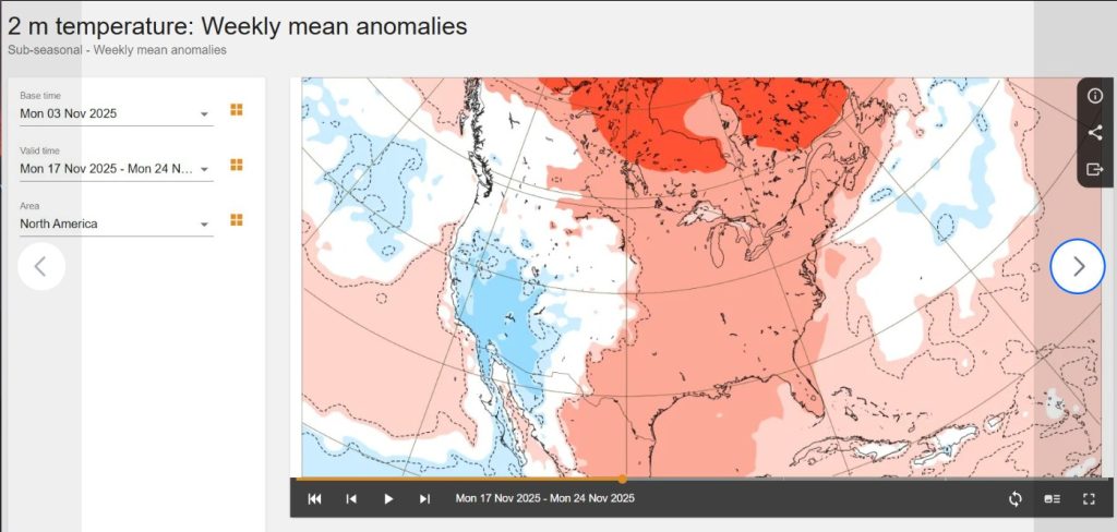
Nerd Note: As we move into November, we normally see temperatures begin to cool substantially (see graph of average temperatures in La Paz from Weatherspark). This year several weather stations in La Paz have continued to record high temperatures of 90-95F over the past couple of weeks, and even here in La Ventana yesterday’s high hovered around 90F. Long-range forecasts from the European Center for Medium Range Forecasting (ECMWF) are showing we will likely continue to see abnormally warm temperatures over the next week or so, however a pattern change in the middle levels of the atmosphere may bring us much cooler weather around November 15 (see graphs below).

Wind – November 3, 2025

¡Buenos dias! A couple of evening passes by the polar orbiting satellites missed BCS, so we’ll have to go solely with the latest batch of numerical model forecasts for today. Although there is some disagreement, a couple of the more reliable models show enough background flow will last through the afternoon, and with sunny skies expected, we should see a windy afternoon. Models continue to show that the surface pressure gradient will weaken substantially tomorrow, and it doesn’t look like we’ll have enough north flow remaining to fully trigger our local wind machine. Surface high pressure from the eastern Pacific is then forecast to build into the Baja Peninsula on Wednesday into Thursday, with solid NNW background flow returning to our region. While models show there may be a substantial west component to this pulse, sunny skies each day should trigger a substantial thermal which will pull the flow onshore. Most of the long-range model forecasts show a quick return to light background flow on Friday into Saturday, but we may see just enough north flow return by Sunday to give us a rideable day.

  • Today…Sunny. North wind 16-18 mph.
  • Tuesday…Sunny. Northeast wind 10-12 mph.
  • Wednesday…Sunny. North wind 16-20 mph.
  • Thursday…Sunny. North wind 18-22 mph.
  • Friday…Sunny. North wind 12-14 mph.
  • Saturday…Sunny. Northeast wind 10-12 mph.
  • Sunday…Sunny. North wind 16-18 mph.