La Ventana Stories

Absent from the Reef and other Videos

As part of my “Eyes on the Reef” campaign series to help people engage with, and discover the amazing diversity that local coral reefs support, I present the following videos:

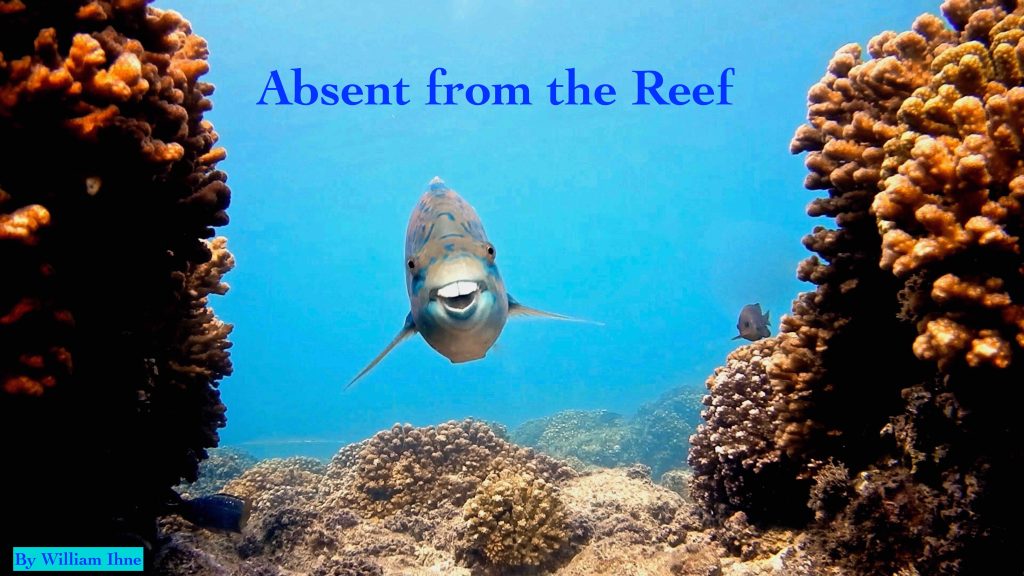
  • My latest, Absent from the Reef, a video tribute to the tremendous adult reef fish schools that once lived at an El Sargento Coral Reef in 2018. The video has a little bit of everything, including fish ID opportunities as resident fish are named, important research data from Mexican Marine Scientists, and it reveals a population baseline for adult fish living at a healthy reef.

    The video asks us to consider the future for local El Sargento reefs, which are some of the most northern coral reefs in North America.

    Here’s a Spanish version of Absent from the Reef! Please share it with your friends.

  • If you enjoy observing and identifying local Eel species, then 10 Eel Species of Baja will help you learn their names. Eels are fascinating creatures. Though at first glance, it’s easy to be alarmed, when a Moray approaches with mouth wide open! Don’t fret, their open mouths help them breath as they pull water inward through their gills. Eels won’t bother you, unless you threaten them. However, I saw one get smacked on the head by another fish, didn’t seem to care. See that smack in this video, Discover Fish Behavior.

  • If you didn’t have a chance to watch my video post two weeks ago, click here: 113 Fish Species ID, a video to help you learn the names of the fish. Keep in mind, you can turn off the music, turn yours on, change the playback speed, make it loop. You can also test your memory with fish name links in the video description. 

  • Here’s a fun short video. I have never seen two Giant Porcupinefish near each other, ever! Watch these remarkable reproductive moves, very much like formal dance. Eye catching!
Parrotfish (herbivores) prevent algae overgrowth which is beneficial to coral.

If you’re interested in going on a Coral Reef Tour with a Marine Scientist, contact me at desertplayer@hotmail.com. Also, to access my public archive posts on the Ventana View, click on this link, Observing the Reef. Bookmark it to keep up with the latest posts, older ones too.

See you at the reefs! Thanks, William

Wind – November 18, 2025

¡Buenos dias! As they say…close but no cigar…as a satellite pass yesterday around noon measured NNW winds over the Sea of Cortez near Cerralvo of only around 5 knots-just short of what is usually needed to fully jump-start our wind machine. Northern beaches only saw winds of around 12-14 mph for much of the afternoon, with a late peak of 15 mph around 3:30 pm. Today will present yet another forecast challenge, as while model forecasts are showing NNW background flow will increase, a band of high clouds will likely move in by late morning and at least partially dampen our local thermal. It’ll once again be close, and if we see some thin spots in the cloud cover, winds could easily be stronger than forecast. Clouds are forecast to become even thicker on Wednesday, and at this point it looks like we will have a very weak thermal at best. Full sunshine will likely return on Thursday, and as a ridge of high pressure builds into the central Baja Peninsula, north winds will increase here. Unfortunately the wind party won’t last long, as model forecasts are in good agreement that a low pressure system lurking off the southern California coast on Friday will push the surface ridge southward directly over BCS, with winds becoming very light. As the low moves slowly eastward across the northern Baja Peninsula on Saturday, our winds will likely remain light. Sunday will be a transition day, as surface high pressure will begin building back into our region with NW background flow increasing. At this point it looks like we’ll still see some west component to the winds on Sunday…stay tuned. Long-range model forecasts are in good agreement that surface high pressure will continue to build to our north, with solid north flow expected over BCS.

(Tides)

  • Today…Sunny this morning, then increasing high clouds. North wind 14-16 mph.
  • Wednesday…Mostly cloudy. North wind 10-12 mph.
  • Thursday…Sunny. North wind 18-22 mph.
  • Friday…Sunny. Northeast wind 8-10 mph.
  • Saturday…Sunny. Northwest wind 8-10 mph.
  • Sunday…Sunny. North/northwest wind 16-18 mph.
  • Monday…Sunny. North wind 18-22 mph.

Wind – November 17, 2025

¡Buenos dias! Substantial breaks in the high cloud cover yesterday allowed our local thermal to produce a great day, with winds at the campground averaging 16-20 mph for around 6 hours straight, peaking at 22 mph around 2 pm. An Oceansat satellite pass late last evening measured NW winds of 15 knots over the Sea of Cortez just east of Cerralvo, but all of the latest numerical model forecasts show decreasing northwest background wind today. While all models show the winds decreasing, several do show just enough will remain and combine with sunny skies to jump start our local wind machine. A slow-moving storm system will affect southern California on Tuesday, then move into Arizona on Wednesday. The latest model forecasts show the effects of this system may stay far enough to our north to allow just enough north background flow to remain tomorrow, and possibly into Wednesday. As that system moves eastward, a ridge of high pressure located near us will retreat northward on Thursday and allow our north winds to increase. At this point it looks like we’ll see just enough north background flow remaining into Friday to give us another windy afternoon. Long-range model forecasts show a stronger storm system will move into the northern Baja Peninsula on Saturday, then continue eastward into northwestern Sonora on Sunday. Flow around this system will likely give us a significant west component to our background flow both Saturday and Sunday.

(Tides)

  • Today..Sunny. North wind 16-18 mph.
  • Tuesday…Sunny. North wind 16-18 mph.
  • Wednesday…Mostly sunny. North wind 14-16 mph.
  • Thursday…Sunny. North wind 18-22 mph.
  • Friday…Sunny. North wind 16-18 mph.
  • Saturday…Sunny. Northwest wind 8-10 mph.
  • Sunday…Sunny. Northwest wind 10-12 mph.

Wind – November 16, 2025

¡Buenos dias! Wind gauges showed a return to a more normal pattern yesterday with marginal background north flow, as the northern beaches peaked at 16-19 mph while southern beaches saw lighter winds…peaking at 14-16 mph. Both Rasta Beach and the campground did show a bimodal shape yesterday, with a notable dip in windspeed around 2:30 pm (see graph from the campground below). An ASCAT pass last evening measured NW winds of around 10 knots just east of Cerralvo, and model forecasts are in good agreement that north background flow will increase today. The wild card in today’s forecast will be the thickness of high cloud cover. Infrared satellite loops early this morning showed a band of high clouds streaming in from the southwest, and model forecasts show significant high cloud cover this afternoon, so our local thermal may be at least partially dampened. For now I’ll be optimistic and say enough filtered sun will make it through to give us a good thermal boost this afternoon. Sunny skies will return on Monday and with sufficient background NNW flow remaining, we should see a windy afternoon. The forecast for Tuesday and Wednesday are tricky, and while there are significant difference in the model forecasts, they generally show low pressure tracking across the western U.S. will force a ridge of high pressure southward and turn our flow more westerly. Model forecasts show a range of solutions Thursday into Friday, but a couple of the more reliable global models show the surface ridge of high pressure will move northward on Thursday into Friday, with our winds becoming more northerly. Long-range model forecasts are in good agreement that surface high pressure will build into the western U.S. on Saturday and bring a new surge of north flow to BCS that could last into the beginning of next week.

(Tides)

  • Today…Mostly sunny. North wind 16-18 mph.
  • Monday…Sunny. North wind 16-18 mph.
  • Tuesday…Mostly sunny. Northwest wind 10-12 mph.
  • Wednesday…Mostly sunny. Northwest wind 10-12 mph.
  • Thursday…Sunny. North wind 16-20 mph.
  • Friday…Sunny. North wind 16-18 mph.
  • Saturday…Sunny. North wind 18-22 mph.

Wind – November 15, 2025

¡Buenos dias! Again the wind gods shone on the southern beaches yesterday, as the gauge at the campground measured solid 16-19 mph winds from 1:30 until 5:30 pm while the gauge at Rasta Beach measured only 12-14 mph for much of the afternoon. A satellite pass around midnight measured NW winds of 5-10 knots near Cerralvo, and most of the latest model forecasts show another day of background flow that will be right on the edge. That said, since Thursday one of the models…the ECMWF…has shown a relatively tight N-S gradient of background flow, with lighter winds just east of the northern tip of Cerralvo, and significantly stronger background flow east of Bahia de los Muertos. Given the significantly lighter winds on northern beaches Thursday and Friday, this suggests that model is verifying well, so we could see similar conditions today. Models continue to show a ridge of high pressure building into the central Baja Peninsula on Sunday, with north flow increasing here. There will be some relatively thin, high clouds streaming in from the southwest on Sunday, but we should see enough filtered sunshine to at least partially trigger our local thermal. The forecast for Monday through Wednesday will depend on the position of the surface ridge, and for now it looks like we may get another good day on Monday, but as the ridge is nudged to the south closer to us, our flow will become more westerly Tuesday and Wednesday. Long-range models show the surface high retreating northward again on Thursday, with solid north background flow returning and possibly lasting through Friday.

  • Today…Sunny. North wind 14-16 mph…stronger south beaches.
  • Sunday…Mostly sunny. North wind 16-18 mph.
  • Monday…Sunny. North wind 16-18 mph.
  • Tuesday…Mostly sunny. Northwest wind 10-12 mph.
  • Wednesday…Mostly sunny. Northwest wind 10-12 mph.
  • Thursday…Mostly sunny. North wind 16-20 mph.
  • Friday…Sunny. North wind 16-18 mph.

Wind – November 14, 2025

¡Buenos dias! In a complete reversal of fortune from Wednesday, wind gauges yesterday showed solid north winds of 16-19 mph from around 11 am until 2:30 pm at the campground, while the gauge at Rasta Beach measured an equivalant 10 minute average wind of only 12-14 mph from around 10 am until around 3:30 pm. An evening pass by one of the ASCAT satellites measured NW winds at 5 knots over the Sea of Cortez near Cerralvo, with NNW winds at 10 knots to the south. Model forecasts are in good agreement that a ridge of high pressure over the central Baja Peninsula and a weak trough of low pressure over the far southeastern Sea of Cortez will combine to tighten the surface pressure gradient and should produce ample north background flow this afternoon over the far southern Sea of Cortez east of the East Cape, northward to Cerralvo Island, with light winds farther north. Model forecasts show that the north background flow may decrease just a bit tomorrow, but with full sunshine expected we may see rideable conditions. The surface ridge to our north is forecast to strengthen on Sunday, with increasing north flow here. It now appears that we may see a bonus day on Monday, as models show the ridge to our north holding fast. Low pressure will move from California into the interior southwest of the U.S. Tuesday into Wednesday, and this will likely push the ridge southward and produce a strong west component in our background wind. Long-range models show surface high pressure again building to our north on Thursday with another pulse of north flow reaching BCS.

  • Today…Sunny. North wind 16-18 mph.
  • Saturday…Sunny. North wind 14-16 mph.
  • Sunday…Sunny. North wind 16-20 mph.
  • Monday…Sunny. North wind 16-18 mph.
  • Tuesday…Mostly sunny. Northwest wind 10-12 mph.
  • Wednesday…Partly sunny. Northwest wind 10-12 mph.
  • Thursday…Mostly sunny. North wind 16-20 mph.

Wind – November 13, 2025

¡Buenos dias! As is often the case with marginal background north wind, yesterday was a tale of 2 bays, as northern beaches peaked at 16-19 mph while the wind gauge at the campground showed 13-16 mph (sometimes only 12 mph). Model forecasts for today show a variety of solutions, but a couple of the more reliable ones show the background north flow falling below the level to fully trigger our afternoon wind machine. Models are in better agreement that Friday will see sufficient north flow to give us a windy afternoon, but Saturday will again be in that zone of maybe yes…maybe no. A weak ridge of high pressure is still forecast to form over the central Baja Peninsula on Sunday, with increasing north flow here. Long-range model forecasts show a slow-moving storm system over California on Monday will push the surface high to our north southward, with our winds becoming more westerly. The low over California will move only slowly eastward on Tuesdsay into Wednesday, so we may see a prolonged period of winds with a significant west component.

  • Today…Sunny. North wind 12-14 mph.
  • Friday…Sunny. North wind 16-18 mph.
  • Saturday…Mostly sunny. North wind 14-16 mph.
  • Sunday…Sunny. North wind 16-20 mph.
  • Monday…Mostly sunny. Northwest wind 10-12 mph.
  • Tuesday…Mostly sunny. Northwest wind 10-12 mph.
  • Wednesday…Mostly sunny. Northwest wind 10-12 mph.

Wind – November, 2025

¡Buenos dias! An Oceansat satellite pass just after midnight measured W to NW winds of 5-10 knots north and east of Cerralvo. Surface analysis showed a relatively weak high pressure system centered over the 4-corners region of the U.S. this morning, and model forecasts show this feature will remain nearly stationary through Saturday. Although the location of the surface high is favorable for substantial north flow over BCS, the weakness of this feature in model forecasts will likely produce only marginal background north flow today through Saturday, and confidence is low that we’ll see enough to fully trigger our local wind machine. That said, sunny to mostly sunny skies could energize our local thermal just enough to bring rideable conditions so best to be ready just in case. Model forecasts are in good agreement that a ridge of high pressure will build into the central Baja Peninsula on Sunday and may give a boost to the north background flow here. Long-range model forecasts generally agree that the ridge of high pressure to our north will then migrate southward over BCS on Monday into Tuesday, with our winds become more westerly.

  • Today…Sunny. North wind 14-16 mph.
  • Thursday…Sunny. North wind 12-14 mph.
  • Friday…Sunny. North wind 14-16 mph.
  • Saturday…Mostly sunny. North wind 12-14 mph.
  • Sunday…Sunny. North wind 16-18 mph.
  • Monday…Sunny. Northwest wind 8-10 mph.
  • Tuesday…Mostly sunny. Northwest wind 8-10 mph.

Wind – November 11, 2025

¡Buenos dias! An evening pass by one of the ASCAT satellites measured west winds at around 5 knots just to the east of Cerralvo, and all of the latest numerical model forecasts show light background flow continuing for today. A relatively weak surface pressure gradient will remain over BCS for the next several days, with generally light winds. There is some indication that we may see a very slight bump in the background flow on Wednesday and Friday, but confidence is low. A weak surface low pressure system is forecast to move slowly across southern California and Arizona Friday into Saturday, and at this point it looks like light winds will continue through Saturday. A noticable change in the weather should occur Saturday night into Sunday as much cooler air will finally move into BCS (see nerd note below). As that happens, a narrow ridge of high pressure is forecast to build to our north with background north flow increasing on Sunday. The north pulse may be short-lived, with light winds returning next Monday.

Today…Sunny. Northeast wind 10-12 mph.
Wednesday…Sunny. North wind 14-16 mph.
Thursday…Sunny. North wind 12-14 mph.
Friday…Sunny. North wind 14-16 mph.
Saturday…Mostly sunny. East wind 8-10 mph.
Sunday…Sunny. North wind 16-20 mph.
Monday…Sunny. Northwest wind 8-10 mph.

Nerd Note: As I mentioned several days ago, long-range global models have been forecasting a major shift in the middle and upper level weather pattern, with much cooler air forecast to finally move into BCS around the middle of November. These forecasts have held, and we should see a noticable cool down here Saturday night into Sunday. The graphics below show the air temperature at around 5000 ft today, with abnormally warm air over much of the western U.S. and Baja Peninsula as a persistent ridge of high pressure remains in place. Notice the trough off the west coast of the U.S., with much cooler air shown in blue. Fast-forward to Sunday and the trough has moved eastward over the Baja Peninsula and temperatures aloft have dropped substantially.

The Multiple Benefits of Birdwatching

Why should folks, young and old, take up birdwatching? Well, if you have accompanied me on even one of my Baja Birding Club outings over the last eight years, you have likely already been convinced. On the other hand, reading my words and spreading them around among family and friends will not only enrich their health, prosperity and well-being but also help the birds themselves and in fact, our entire planet. And all for a very low initial financial investment! 

Let’s delve into this more deeply. A team of German scientists conducted a study based on socio-economic data from more than 26,000 adults from 26 European countries and concluded that avian diversity is as important for their life satisfaction as their income, and that one’s surroundings, i.e. plenty of somewhat natural and diverse landscapes that hold numerous green spaces and bodies of water that promote bird life, was equally valued, which in turn leads to higher property values. 

Being a birdwatcher might even help you to live longer by making those walks in the great outdoors healthier. A study led by a scientist from Carleton University found that hearing birdsong while hiking outdoors improves people’s overall well-being more than if they hiked without hearing birds chirping. But seeking out and identifying birds while hiking is even better! As recently as 2024, a study from North Carolina State University discovered that birdwatching leads to higher subjective well-being and a greater reduction in distress than compared to generic nature experiences like walking. This was especially true for college students who are often at risk for mental health issues. Even cancer patients have learned that birdwatching is therapeutic. One patient said that just being outside and enjoying the bird life helped distract him thoroughly from his medical challenge. Another cancer patient losing her hair decided to donate the fallen locks to the birds for nest-building. It made her feel good. Birdwatching can also be highly beneficial to those with dementia. It helps them to get outside, enjoy the beauty and tranquility of nature, become more mindful of themselves and their environment, loosen arthritic joints and improve their cardiovascular function, provides a sense of achievement, and allows interaction with other like-minded folks. Like crossword puzzles, the mental process of identifying birds and keeping list might even stave off dementia. Why, even blind people can appreciate birds! Many of the world’s best birders probably hear and list more birds by their calls and songs than by seeing them. Juan Pablo Culasso, a Uruguayan who was born blind, can identify more than 2,000 different kinds of birds and he leads a team in Colombia to build birding trails for visually impaired birders. 

Speaking of other countries, birdwatching has taken me all over the world from the savannah of Kenya to the cloud forest of Costa Rica and to here in Baja Mexico. I now have bird-loving friends in more than fifty countries! 

As for the bigger picture, despite the fact there are an estimated 50 million birdwatchers in North America alone, the world can never have enough birdwatchers. Our birds are in serious trouble. More than 12 percent of the world’s 11,000 bird species are in critical danger of extinction! To help keep them as part of our landscapes here and abroad, we need careful monitoring of their status so that successful conservation and management actions can be implemented. Becoming a birder, no matter how skilled, allows one to join the burgeoning ranks of citizen scientists helping professional ornithologists keep track of bird populations and their status and health all over the globe. More importantly, birds simply need more voices among political circles to ensure their preservation. 

In conclusion, become a birdwatcher to save yourself, save the birds, and save the planet! 

Submitted by David M. Bird, Emeritus Professor of Wildlife Biology, McGill University, Montreal