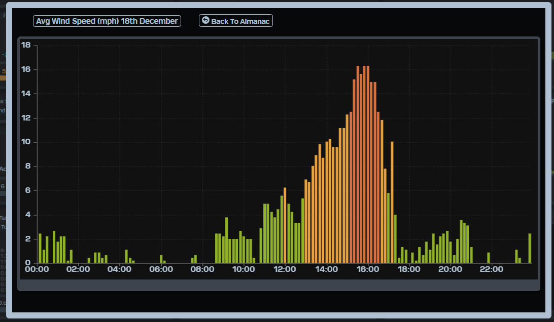
Wind – October 24, 2025

Note: I will be out of network range on Saturday, so the forecast will not be updated until Sunday morning.

¡Buenos dias! Satellite passes last evening measured south winds of around 5 knots over much of the southern Sea of Cortez. A relatively weak area of high pressure was centered near Salt Lake City early this morning, and model forecasts are in good agreement that this feature will build south…southeastward today, bringing marginal NNE background flow to our region by mid afternoon. It’ll likely be one of those days right on the edge of rideable, as models also show full sunshine is expected. The weak surface high is then forecast to build into western New Mexico on Saturday and further tighten the surface pressure gradient over BCS, with north background flow increasing here. Solid north flow is expected to continue through Sunday as the surface high remains nearly stationary to our north, and with another sunny day expected, we should see a windy afternoon. Forecast models are in good agreement that a new area of high pressure will build into the Pacific Northwest of the U.S. on Monday, then into the interior west of the U.S. on Tuesday. This will likely keep solid north background flow over BCS through at least Tuesday and with sunny skies expected our local thermal should be in fine form each afternoon. Long-range model forecasts are in good agreement that the surface pressure gradient will become weak on Wednesday, with light background flow continuing into Thursday.

  • Today…Sunny. Northeast wind 12-14 mph…maybe more.
  • Saturday…Sunny. North wind 16-18 mph.
  • Sunday…Sunny. North wind 16-20 mph.
  • Monday…Sunny. North wind 16-18 mph.
  • Tuesday…Sunny. North wind 16-18 mph.
  • Wednesday…Sunny. East wind 8-10 mph.
  • Thursday…Sunny. East wind 8-10 mph.

Wind – October 23, 2025

¡Buenos dias! After another 5+ hours of great conditions yesterday, today will be a rest day as a satellite pass late last evening confirmed model forecasts of relatively light background flow over the southern Sea of Cortez. Models show a weak surface high will begin to build into the western U.S. on Friday, but it looks like only marginal northeast flow at best will reach us. The surface high is forecast to move into the 4-corners region on Saturday, and this should tighten the surface pressure gradient over BCS just enough to jump start our local wind machine. Model forecasts are in good agreement that sufficient north background flow should then last for several days as a weak ridge of high pressure remains to our north. Long-range forecasts indicate that winds may become marginal again by next Wednesday.

  • Today…Sunny. East wind 8-10 mph.
  • Friday…Sunny. Northeast wind 10-12 mph.
  • Saturday…Mostly sunny. North wind 16-18 mph.
  • Sunday…Mostly sunny. North wind 16-20 mph.
  • Monday…Sunny. North wind 16-18 mph.
  • Tuesday…Sunny. North wind 16-18 mph.
  • Wednesday…Sunny. North wind 14-16 mph.

Wind – October 22, 2025

¡Buenos dias! Yesterday was a ‘chamber of commerce’ day, as the wind gauge at the campground measured 18-23 mph sustained winds for a solid 6 hours from around 11 am until 5 pm. A satellite pass late last evening measured background flow of 10-15 knots over the Sea of Cortez east of Cerralvo, and although the latest forecast models show the background flow will decrease today, there will likely be plenty of north flow remaining for another good day. Satellite loops early this morning indicated another sunny day ahead, so once again our wind machine should kick by midday. Surface high pressure centered over Colorado this morning will weaken rapidly tonight, and the surface pressure gradient will become very weak over BCS on Thursday, with only light onshore flow expected. Model forecasts show surface high pressure building back into the interior west of the U.S. on Friday, with marginal north to northeast background flow returning to our area. At this point the weekend looks good, with NNW background flow increasing Saturday and lasting into Sunday, and with mostly sunny skies expected, we should see substantial thermal boosts each day. At this point long-range model forecasts show sufficient north flow may continue through Tuesday.

  • Today…Sunny. North wind 16-20 mph.
  • Thursday…Sunny. East wind 8-10 mph.
  • Friday…Mostly sunny. North wind 14-16 mph.
  • Saturday…Sunny. North wind 16-18 mph.
  • Sunday…Mostly sunny. North wind 16-20 mph.
  • Monday…Mostly sunny. North wind 16-18 mph.
  • Tuesday…Sunny. North wind 16-20 mph.

Wind – October 21, 2025

¡Buenos dias! An evening satellite pass measured solid NNW winds of 10 knots over much of the southern Sea of Cortez. The latest batch of model forecasts shows that background flow will increase a bit today as surface high pressure centered near Salt Lake City early this morning builds southeastward and the surface pressure gradient over BCS tightens. Infrared satellite loops indicated only a few patches of mid-level clouds to our east, and model forecasts show only a few thin, high clouds possible late this afternoon so our local thermal should be in fine form. The surface pressure gradient is forecast to weaken on Wednesday, but at this point it looks like we’ll still see sufficient background north flow to help trigger another windy afternoon. Thursday looks like a down day, as models show only light onshore flow. A relatively weak surface high pressure system is then forecast to build into the interior west of the U.S. on Friday, with marginal north background flow returning to our region. The weak surface high will then build into the 4-corners region on Saturday, with north flow likely increasing a bit here. At this point it appears that solid north flow will continue through Sunday, with winds deacresing again on Monday.

  • Today…Sunny. North wind 18-22 mph.
  • Wednesday…Sunny. North wind 16-18 mph.
  • Thursday…Sunny. East wind 8-10 mph.
  • Friday…Sunny. North wind 14-16 mph.
  • Saturday…Sunny. North wind 16-18mph.
  • Sunday…Mostly sunny. North wind 16-20 mph.
  • Monday…Mostly sunny. North wind 14-16 mph.

Wind – October 20, 2025

¡Buenos dias! An overnight satellite pass measured NNW winds of 10-15 knots over the Sea of Cortez just east of Cerralvo. While the latest numerical model forecasts show the background flow will be less than we saw yesterday, it now appears that there will still be enough this afternoon to help trigger our local wind machine. Mid-level clouds this morning are forecast to move off to the north by around midday, so we should get a substantial thermal boost as well. Surface high pressure centered over the Pacific Northwest of the U.S. this morning is forecast to build quickly southeastward into the 4-corners area on Tuesday and tighten the surface pressure gradient over BCS. With full sunshine expected on Tuesday, we should see our thermal in fine form (see nerd note below). Just enough north flow should last into Wednesday to give us one more rideable day, then the surface pressure gradient will likely become weak, leaving us with light winds Thursday into Friday. Long-range model forecasts show a weak ridge of high pressure may form just to our north, with some north background flow possibly returning Saturday and Sunday.

  • Today…Some morning clouds then becoming mostly sunny. North wind 16-18 mph.
  • Tuesday…Sunny. North wind 16-20 mph.
  • Wednesday…Sunny. North wind 16-18 mph.
  • Thursday…Sunny. East wind 8-10 mph.
  • Friday…Mostly sunny. Northeast wind 10-12 mph.
  • Saturday…Mostly sunny. North wind 16-18mph.
  • Sunday…Mostly sunny. North wind 16-18mph.

Nerd Note: Several of you have asked if the very green desert we have now, especially compared to last year, will affect our local thermal this year. The answer is yes, but it remains to be seen how much. It is well documented that a green surface stays substantially cooler than a bare surface. This is primarily due to a process called transpiration, where liquid water is evaporated from plant tissues. A phase change from liquid water to water vapor requires a large amount of heat, and as transpiration occurs, it tends to cool the surrounding air and with cooler air, our local thermal would be weaker. That’s the science of it, and it’ll be interesting to see how significant the effect is here. So far so good, as the thermal boost to the background flow we saw yesterday was very similar to what we saw last season.

Wind – October 19, 2025

¡Buenos dias! The wind gauge at the campground yesterday showed a relatively unusual profile, as winds made a very slow climb to around 14 mph with gusts to 16 mph by around 2 pm, then began a steeper climb around 3 pm, reaching a peak of 17 mph with gusts to 21 mph fairly late at 5 pm. A series of polar orbiting satellite passes yesterday afternoon showed yesterday’s late show was driven by a substantial increase in the background flow, as opposed to our normal thermally-driven peak. An Oceansat satellite pass shortly after midnight last night showed solid 15 knot NNW background flow just east of Cerralvo, and recent model forecasts show similar background flow will continue today. Infrared satellite loops early this morning indicated clear skies across our region, so with full sunshine expected, we will likely see a significant thermal boost much earlier than yesterday’s late show. Models forecasts show that the remainder of the week will bring an on again…off again pattern as surface high pressure to our north weakens and builds again. At this point Monday looks marginal, but we will likely see another solid pulse of north background flow on Tuesday. The middle of the week will likely again see marginal conditions, then another pulse of north flow may arrive on Friday. At this point Saturday looks like another light wind day.

  • Today…Sunny. North wind 18-22 mph.
  • Monday…Sunny. North wind 14-16 mph.
  • Tuesday…Mostly sunny. North wind 16-20 mph.
  • Wednesday…Mostly sunny. North wind 14-16 mph.
  • Thursday…Sunny. Northeast wind 10-12 mph.
  • Friday…Sunny. North wind 16-18 mph.
  • Saturday…Sunny. East wind 8-10 mph.

Wind – October 18, 2025

¡Buenos dias! An overnight pass by the Indian Oceansat satellite showed north winds over the Sea of Cortez had pushed as far south as Loreto, and all of the latest numerical model forecasts show north background flow becoming established over all of the southern Sea of Cortez this afternoon. Infrared satellite loops showed clear skies in our region, and this will set the stage for a significant thermal boost as well. Surface high pressure currently centered over the Pacific Northwest of the U.S will move rapidy southeastward on Sunday, and this will tighten the surface pressure gradient over BCS, and with full sunshine expected we should see a windy afternoon. Model forecasts show that the rest of the upcoming week will see a series of storm systems affecting southwestern Canada and the Pacific Northwest of the U.S., with surface high pressure over the interior west of the U.S. building and weakening slightly as storms pass to the north. At this point it looks like Monday and Wednesday will see the weakest background flow, but otherwise the global models show enough north flow over the southern Sea of Cortez to bring us rideable days through Friday.

  • Today…Sunny. North wind 16-18 mph.
  • Sunday…Sunny. North wind 18-22 mph.
  • Monday…Sunny. Northeast wind 14-16 mph.
  • Tuesday…Mostly sunny. North wind 16-18 mph.
  • Wednesday…Mostly sunny. North wind 14-16 mph.
  • Thursday…Sunny. North wind 16-18 mph.
  • Friday…Mostly sunny. North wind 16-18 mph.

Wind – October 17, 2025

¡Buenos dias! Well, there’s good news and bad news. First the bad…the wind forecast for today looks significantly lighter. An overnight satellite pass measured light and variable winds over the southern Sea of Cortez, and although some of the latest model forecasts do show the background flow becoming northerly by around midday, significant low cloud cover is expected over the plains this afternoon and that will likley keep our local wind machine from really kicking in. Now the good…models continue to show surface high pressure building into the interior west of the U.S. this weekend, with a tightening surface pressure gradient over BCS. Sufficient north flow is now expected to continue through at least Tuesday, so we should see a nice stretch of kiteable days. Long-range model forecasts disagree, but we may see marginally rideable winds through Thursday…stay tuned.

  • Today…Partly sunny. North wind 12-14 mph.
  • Saturday…Mostly sunny. North wind 16-18 mph.
  • Sunday…Sunny. North wind 18-22 mph.
  • Monday…Sunny. Northeast wind 16-18 mph.
  • Tuesday…Mostly sunny. North wind 16-18 mph.
  • Wednesday…Mostly sunny. North wind 14-16 mph.
  • Thursday…Sunny. North wind 14-16 mph.

Wind – October 16, 2025

¡Buenos dias! Yesterday afternoon the wind gauge at the campground peaked at sustainted winds of 17 mph with gusts to 20 mph (big thanks for the ground truth there). Satellite-derived winds late last evening showed NNW winds of around 10 knots over much of the central and eastern Sea of Cortez, with typical summer-early fall overnight west flow closer to Cerralvo. The latest numerical model forecasts for today show weaker north background flow than yesterday, with a northeast to east wind developing this afternoon. That said it’ll be close, and I wouldn’t be surprised to see kiteable winds for a few hours during the afternoon. As surface high pressure builds into the western U.S. on Friday, we should see a bit more north background flow…possibly enough to help fully trigger our local wind machine. At this point the weekend is looking good, as the surface high centered far to our north continues building into the interior western U.S. and the surface pressure gradient tightens over BCS. Long-range model forecasts agree that by Monday the surface pressure gradient over BCS will weaken as we are caught between high pressure centered far to our north over Oregon, and a weak tropical system near Socorro Island far to our south. At this point the vast majority of model forecasts show the tropical system will continue moving westward and pass far to our south (see nerd note below), with only a few clouds streaming in Monday through Wednesday. The high centered over Oregon on Monday is forecast to rapidly build southeastward on Tuesday, with north background flow likely returning here. Although the surface pressure gradient is then forecast to weaken on Wednesday, we may see just enough north flow remaining for one more kiteable day.

  • Today…Sunny. Northeast wind 12-14 mph.
  • Friday…Sunny. North wind 16-18 mph.
  • Saturday…Sunny. North wind 16-20 mph.
  • Sunday…Sunny. North wind 18-22 mph.
  • Monday…Mostly sunny. Northeast wind 10-12 mph.
  • Tuesday…Mostly sunny. North wind 16-18 mph.
  • Wednesday…Mostly sunny. North wind 14-16 mph.

Nerd Note: Most of the computer model forecasts for tropical cyclone track and intensity use a vast array of current observations and complex physics to predict the future path and intensity of these storms. Google DeepMind has recently launched a model that takes a different approach. Using AI and a huge dataset of past storms and surrounding atmospheric conditions, Google’s Weather Lab predicts up to 50 solutions for the path and intensity of any tropical cyclone worldwide. Their method has shown great promise, and is being used experimentally as part of the forecast arsenal at the National Hurricane Center in Miami. I’ve attached a couple of links in the comments (note…facebook now deletes most external links embedded in a post, so a work-around is to put it in the comments section).

Wind – October 15, 2025

¡Buenos dias and welcome back for another season here in beautiful La Ventana! After a couple of late-season tropical systems, north flow has finally returned, and it looks like we’ll have a good week ahead. Forecast models show surface high pressure centered far out in the Pacific will build into the interior west of the U.S. over the next several days and bring us north…northwest background flow through Saturday. Full sunshine each day should trigger our local thermal and pull any remaining west out of the background flow by early afternoon. The surface high is then forecast to continue building eastward into Colorado on Saturday and New Mexico by Sunday, bringing continued solid north background flow to BCS. The forecast gets a bit muddier on Monday into Tuesday as the tropics may again come into play. While uncertainty is high, some forecast models, including Google’s DeepMind tropical cyclone model (a powerful AI model that has shown great success), are showing the possibility of a late-season tropical system approaching BCS early next week. I want to stress that it is WAY too early to be certain, but we may see the north flow weaken substantially Monday into Tuesday.

Again, I want to welcome all of you back to MasViento, and I’m looking forward to spending another amazing season with you here in our incredible community. For those of you getting ready to make the journey south, ¡Buen viaje!

  • Today…Sunny. North wind 16-18 mph.
  • Thursday…Sunny. North wind 16-18 mph.
  • Friday…Sunny. North wind 16-18 mph.
  • Saturday…Sunny. North wind 16-20 mph.
  • Sunday…Sunny. North wind 16-20 mph.
  • Monday…Mostly sunny. Northeast wind 12-14 mph.
  • Tuesday…Mostly sunny. Northeast wind 10-12 mph.