Wind – December 12, 2025

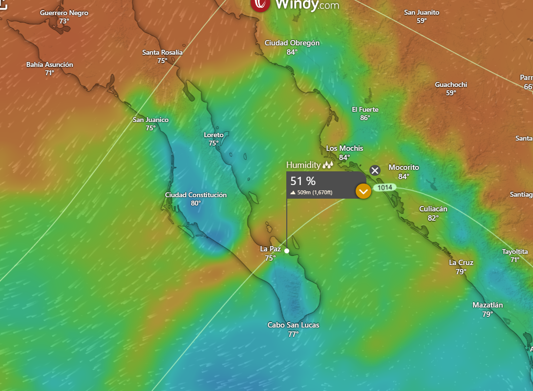
¡Buenos dias! None of the wind-measuring satellites passed over BCS last evening, but all of the latest model forecasts show the near perfect conditions of yesterday will continue for almost another week. There may be a few thin, high clouds at times on Monday, but otherwise look for sunny skies each day, with our local thermal in fine form. The surface high that is locked in place to our north will remain there through Tuesday, then begin to move southward and weaken on Wednesday. At this point the long-range model forecasts are in good agreement that we'll see light winds on Thursday as the surface pressure gradient becomes weak.

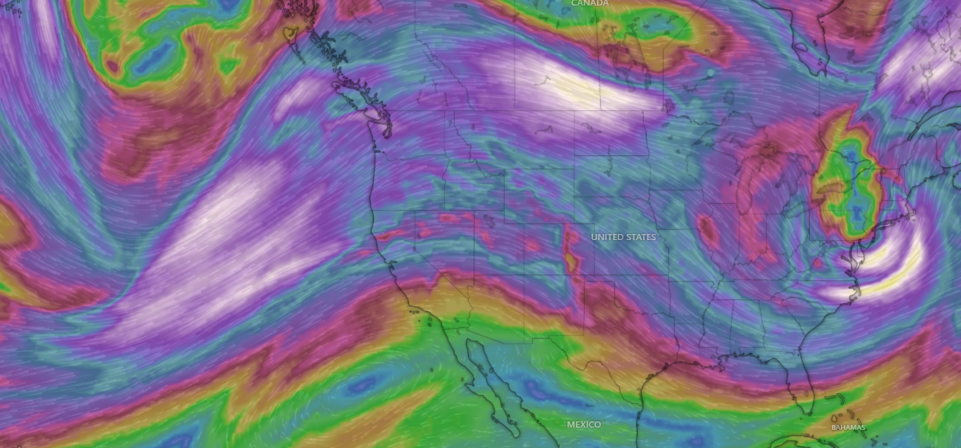
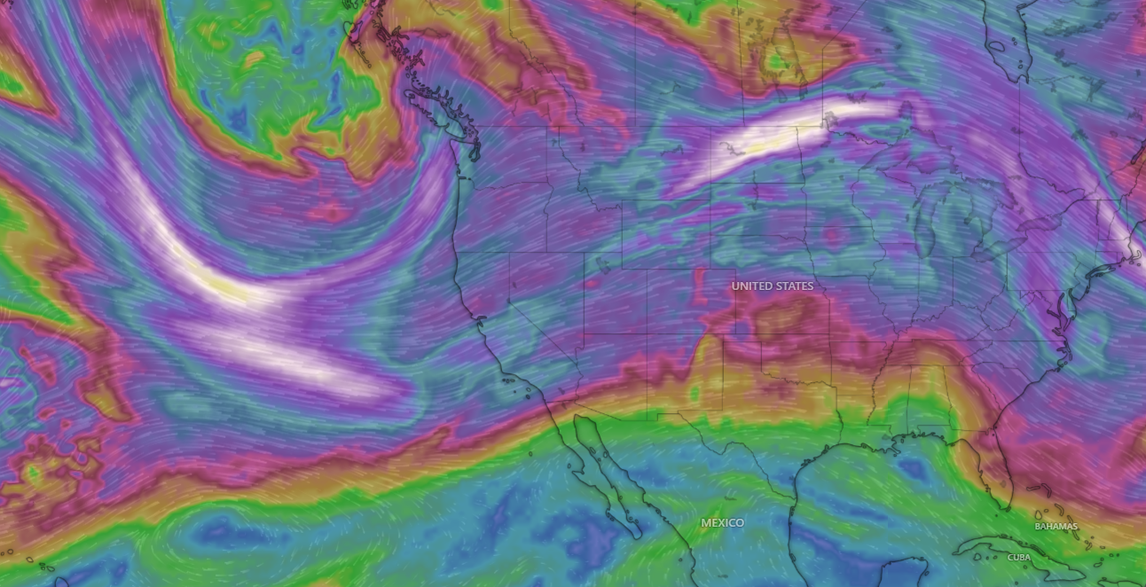
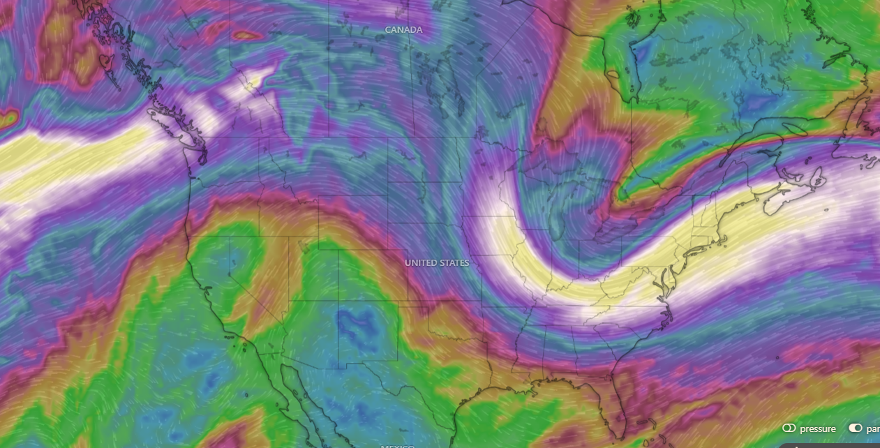
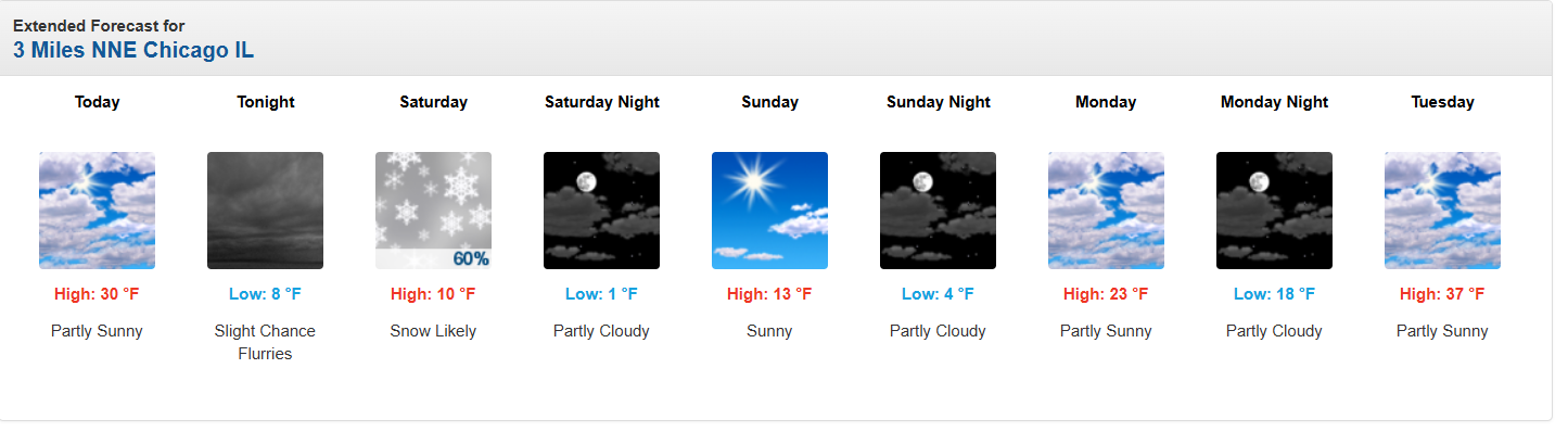
Nerd Note: The strong ridge of high pressure parked over much of the western U.S. will continue to bring near record warmth to areas of the Sierras, while to the east, a corresponding deep trough of low pressure will allow more arctic air to plunge into the midwest of the U.S. Below is a graphic showing the forecast wind pattern and speed for Sunday at about 20,000 ft above sea level, and the National Weather Service 7-day forecasts for Kirkwood ski resort (Lake Tahoe) at 9000 ft, and for Chicago.


(Tides)
  • Today…Sunny. North wind 18-22 mph.
  • Saturday…Sunny. North wind 18-22 mph.
  • Sunday…Sunny. North wind 18-22 mph.
  • Monday…Mostly sunny. North wind 16-20 mph.
  • Tuesday…Sunny. North wind 18-22 mph.
  • Wednesday…Sunny. North wind 16-20 mph.
  • Thursday…Sunny. Northeast wind 10-12 mph.

Wind – December 11, 2025

***********SWAG…SWAG…SWAG***************

Thanks to our good friends Ken and Donna, we will have a new batch of MasViento caps and t-shirts for sale today at the No Mas Basura recycle day located just behind (west and upslope) of the Farmers’ Market. Caps are $25 and t-shirts are $20. ALL profits go to No Mas Basura for the amazing work they do in our community. Come and get yours! 

¡Buenos dias! An ASCAT pass last night measured NNW winds of 15 knots near Cerralvo, and forecast models are again in excellent agreement that this latest streak of windy days will continue. Surface high pressure over the western U.S. will remain nearly stationary through at least next Tuesday and bring solid north background flow to BCS. Some thin, high clouds may tend to dampen our local thermal a bit Saturday through Monday, but we should see enough filtered sun each day to get at least a partial thermal boost. Full sunshine should return on Tuesday, and with ample north background flow continuing, we should see another windy day. The long-range model forecasts are in good agreement that the surface high will begin to weaken on Wednesday, with light winds returning as early as next Thursday.

(Tides)

  • Today…Sunny. North wind 18-22 mph.
  • Friday…Sunny. North wind 16-20 mph.
  • Saturday…Mostly sunny. North wind 16-18 mph.
  • Sunday…Mostly sunny. North wind 16-18 mph.
  • Monday…Mostly sunny. North wind 16-18 mph.
  • Tuesday…Sunny. North wind 18-22 mph.
  • Wednesday…Sunny. North wind 16-18 mph.

Wind – December 10, 2025

¡Buenos dias! NNW winds of 10-15 knots were measured near Cerralvo by a couple of evening satellite passes, and all of the latest model forecasts show solid NNW background flow will continue today. A few morning high clouds should move off to the east, with a significant thermal boost expected this afternoon. Models are in excellent agreement that high pressure over the western U.S. will remain locked in place through the upcoming weekend and likely through next week as well, with ample north background flow continuing over our region (see nerd note below). Some high clouds may partially dampen our local thermal on Sunday and Monday, but otherwise we should see substantial thermal boosts each afternoon.

Nerd Note: A weather phenomenon known as a blocking pattern has been present over parts of the western U.S. for the past several weeks, and this pattern is expected to continue through at least next week. A large ridge of high pressure in the middle and upper levels of the atmosphere over California has deflected storm systems from the Pacific northward into northern Oregon and Washington with flooding rains there, however to the south, little or no precipitation has occured since the middle of November. The first graphic below shows the wind pattern this morning at 500 millibars, which is around 20,000 feet above sea level. Note the large ridge over California and the deep trough over the eastern U.S. By Friday, December 19, the ridge is still in place (second graphic), but extended range model forecasts are showing the possibility of a pattern change by Christmas week (third graphic), with rain and snow possibly returning to California.

(Tides)
  • Today…Mostly sunny. North wind 18-22 mph.
  • Thursday…Sunny. North wind 16-20 mph.
  • Friday…Sunny. North wind 16-20 mph.
  • Saturday…Sunny. North wind 16-20 mph.
  • Sunday…Mostly sunny. North wind 16-18 mph.
  • Monday…Mostly sunny. North wind 16-18 mph.
  • Tuesday…Sunny. North wind 18-22 mph.

Wind – December 9, 2025

¡Buenos dias! A partial pass by one of the ASCAT satellites last evening measured NNW winds of 15-20 knots near Cerralvo, and model forecasts are in excellent agreement that solid NNW background flow will continue today. Infrared satellite loops early this morning showed a few patches of thin, high cloud moving in from the southwest, but forecasts show we should see plenty of sunshine this afternoon. There was still enough of a west component to the winds yesterday afternoon that produced gusty, uneven winds near shore at the northern beaches, but mid afternoon winds were stronger and much steadier about a 1/2 mile offshore (personal observation). Several of the model forecasts show a bit less west component to the background flow today, so hopefully we'll see better quality winds there today. The forecast through the upcoming weekend remains unchanged, as model forecasts are in excellent agreement that surface high pressure will remain locked in place over the western U.S. Our background NNW flow will gradually weaken a bit beginning on Thursday, but there should be ample wind left through Monday to combine with sunny to mostly sunny skies and keep our local wind machine in fine form.

(Tides)
  • Today…Mostly sunny. North wind 18-22 mph.
  • Wednesday…Sunny. North wind 18-22 mph.
  • Thursday…Sunny. North wind 16-20 mph.
  • Friday…Sunny. North wind 16-18 mph.
  • Saturday…Mostly sunny. North wind 16-18 mph.
  • Sunday…Mostly sunny. North wind 16-18 mph.
  • Monday…Mostly sunny. North wind 16-20 mph.

Wind – December 8, 2025

¡Buenos dias! An evening pass by one of the ASCAT satellites measured 15 knot NNW winds just east of Cerralvo, with stronger winds to the north…reaching 25 knots east of Loreto. An large ridge of high pressure extended from the eastern Pacific well into the west-central U.S. this morning, and with a tight surface pressure gradient over BCS, we will see a very windy afternoon. A few thin, high clouds will stream overhead from time to time, but there should be ample sunshine to trigger our local thermal and help pull most of any remaining west component out of the wind. As bad as the wind was last week, this week will be on the other end of the sptectrum as all of the latest model forecasts show the ridge of high pressure to our north will remain nearly stationary through next weekend and only gradually weaken. At this point it looks like enough north background flow will last through Sunday to continue the streak of windy days. Extended range models show the wind party may last through the following week as well, as surface high pressure remains locked in place to our north.

(Tides)
  • Today…Mostly sunny. North wind 20-24 mph.
  • Tuesday…Mostly sunny. North wind 18-22 mph.
  • Wednesday…Sunny. North wind 18-22 mph.
  • Thursday…Sunny. North wind 16-20 mph.
  • Friday…Mostly sunny. North wind 16-20 mph.
  • Saturday…Mostly sunny. North wind 16-18 mph.
  • Sunday…Mostly sunny. North wind 16-18 mph.

Wind – December 7, 2025

¡Buenos dias! Mostly sunny skies gave us a bonus day yesterday (see nerd note below) and all of the latest numerical model forecasts show abundant sunshine will continue today. Surface high pressure centered over northern Utah this morning will send solid north background flow into BCS, and a sunny afternoon will bring us an added thermal boost. The remainder of the forecast remains unchanged as the surface high far to our north remains parked over the western U.S. and N to NNW background winds continue for our region. A few thin, high clouds are still likely on Tuesday, but otherwise sunny skies are expected through Friday. At this point it lookds like the surface high will weaken on Saturday, and with increasing high clouds we should see winds diminish here.

Nerd Note: The substantial cloud cover I thought would likely form yesterday afternoon luckily didn't materialize, and with sunny skies for most of the day we saw our local thermal quickly kick in. A visible satellite loop from late morning through mid-afternoon (see below) showed the plains to our south and southwest remained clear while abundant cloud cover nearly surrounded that area. While the satellite loop does show abundant low-level moisture, it took just a bit of lift from higher terrain surrounding the plains to form clouds as the north background flow moved over the region. Closer to La Ventana, you can see lots of clouds locked-in over the Cacachilas Mountains to our northwest, and also a line of cumulus clouds formed by the higher terrain on Cerralvo streaming southward to just west of the lighthouse.

(Tides)
  • Today…Mostly sunny. North wind 18-22 mph.
  • Monday…Sunny. North wind 20-24 mph.
  • Tuesday…Mostly sunny. North wind 18-22 mph.
  • Wednesday…Sunny. North wind 18-22 mph.
  • Thursday…Sunny. North wind 16-20 mph.
  • Friday…Sunny. North wind 16-20 mph.
  • Saturday…Partly sunny. North wind 14-16 mph.

Wind – December 6, 2025

¡Buenos dias! Local rain gauges showed storm total rainfall over the past 2 days was right around 1 inch, and the latest batch of model forecasts show that while we may see some light showers or sprinkles today, the bulk of the rain is over. Satellite passes measured north winds of around 10 knots near Cerralvo late last evening, and models show similar background flow will continue today. While this would normally be more than enough to trigger our local wind machine, satellite images show abundant low-level clouds remain over our region, and model forecasts indicate that significant low clouds are likely to last through this afternoon…effectively putting a damper on our local thermal. Of course if we see (unexpected) significant breaks in the cloud cover this afternoon, we could see rideable winds so best to be ready just in case. This rare long stretch of cloudy, rainy, no wind days will finally come to an end on Sunday as surface high pressure builds into the interior western U.S. and drier air filters into BCS. Model forecasts are in good agreement that not only will the background north flow increase significantly on Sunday, but the atmosphere will dry out as well, leaving mostly sunny skies. The graphics below show the relative humidity at around 5000 ft this aftermoon, then much drier air for Sunday. Model forecasts are in good agreement that the surface high to our north will then remain parked there for much of the remainer of the week, and with abundant sunshine expected each day, we should see a great stretch of windy days ahead.

(Tides)
  • Today…Mostly cloudy with a few showers possible. North wind 10-12 mph.
  • Sunday…Mostly sunny. North wind 18-22 mph.
  • Monday…Sunny. North wind 20-24 mph.
  • Tuesday…Mostly sunny. North wind 18-22 mph.
  • Wednesday…Sunny. North wind 18-22 mph.
  • Thursday…Sunny. North wind 16-20 mph.
  • Friday…Sunny. North wind 16-20 mph.

Wind – December 5, 2025

¡Buenos dias! Rain gauges from La Paz south to Todos and over to Cabo measured generally 0.75 to 1 inch of rain last night. Due to the power outage, the only local gauge available this morning was at the campground, and it has measured 0.42 inches so far. Cabo weather radar (see image below from around 6 am) showed widespread light to moderate rain continuing to move into southern BCS, and the latest model forecasts show periods of rain continuing for us through today. The big change in the forecast is that the strong storm system bringing us all of this rain and cloud cover has slowed in its eastward progression, so now it looks like we'll have one more day of clouds and possible showers on Saturday. The good news is that all of the latest model forecasts continue to show the storm system finally exiting our region on Sunday, as as surface high presure builds into BCS, we'll see increasing north background flow and mostly sunny skies by Sunday afternoon. A great stretch of windy days is then forecast for our area, as surface high pressure will remain anchored over the interior west of the U.S. from Monday into at least Thursday with solid north background flow continuing here. Other than a few thin, high clouds on Tuesday, we should see sunny skies each day Monday-Thursday, with signficant thermal boosts each day.


(Tides)
  • Today…Cloudy with periods of rain. Light and variable wind.
  • Saturday…Mostly cloudy with showers possible. North wind 10-12 mph.
  • Sunday…Mostly sunny. North wind 18-22 mph.
  • Monday…Sunny. North wind 20-24 mph.
  • Tuesday…Mostly sunny. North wind 18-22 mph.
  • Wednesday…Sunny. North wind 18-22 mph.
  • Thursday…Sunny. North wind 16-20 mph.

Wind – December 4, 2025

¡Buenos dias! Satellite passes last evening measured light southerly winds over the Sea of Cortez near Cerralvo, and all of the latest model forecasts show light and variable winds will continue today. Thick cloud cover will also persist as moisture circulating around a strong mid and upper-level low to our west is drawn up from the southwest. Light rain will likely develop this afternoon and continue tonight as the low approaches BCS. Most of the models show the bulk of the rain will move off to the southast on Friday, but we may see some lingering light rain or sprinkles. The weak surface pressure gradient over our area will begin to tighten a bit on Friday, but cloud cover will significantly dampen our local thermal. Models are in good agreement that north background flow will increase on Saturday, and with the return of mostly sunny skies we should see a windy afternoon. Surface high pressure will continue building into the interior west of the U.S. on Sunday then remain nearly stationary through Wednesday, with solid north background flow. Other that a few thin, high clouds on Tuesday, we should see sunny skies Sunday through Wednesday so our much-missed local thermal will be in fine form.

(Tides)
  • Today…Cloudy with rain likely…especially this afternoon and tonight. Light and variable wind.
  • Friday…Mostly cloudy with light rain or sprinkles likely. North wind 12-14 mph.
  • Saturday…Mostly sunny. North wind 18-22 mph.
  • Sunday…Sunny. North wind 20-24 mph.
  • Monday…Sunny. North wind 18-22 mph.
  • Tuesday…Mostly sunny. North wind 18-22 mph.
  • Wednesday…Sunny. North wind 16-20 mph.

Wind – December 3, 2025

¡Buenos dias! Polar-orbiting satellites measured light WNW winds over the Sea of Cortez near Cerralvo last evening, verifying model forecasts of a weak background flow. The forecast has remained virtually unchanged, as a strong mid and upper-level low pressure system west of the Baja Peninsula this morning (see nerd note below) will move eastward over the next several days. The very weak surface pressure gradient and resulting light background wind we see this morning over BCS will last through at least Thursday. Abundant cloud cover will again be the rule today as moisture circulating around the low to our west overspreads our region. As the low draws closer on Thursday, models continue to show the chance for rain increasing. Although surface high pressure will build into the interior west of the U.S. on Friday and tighten the surface pressure gradient over BCS, residual low level moisture will likely lead to significant low clouds and even some light showers, with our local thermal significantly dampened. Model forecasts are in excellent agreement that the bulk of the cloud shield will finally move off to our east on Saturday, and with ample north background flow we should see a windy afternoon. Long-range model forecasts show a reinflorcing surface high is then forecast to build into the western U.S. on Sunday and give us solid north background flow into next week.

Nerd Note: Modern satellites have the capability to measure water vapor content in multiple layers of the atmosphere. As an example, here is an early morning loop from the NOAA GOES 18 satellite's mid-level moisture sensor.

Red shades are dry, white to blue shades show abundant moisture, and the red and yellow areas are likely thunderstorms.

Note the very distinctive counter-clockwise circulation west of the Baja Peninsula, and the moisture being drawn up from the southwest over the Baja Peninsula. This is what models are showing will move eastward and likely bring rain to our region Thursday into Friday.

(Tides)
  • Today…Mostly cloudy with a few sprinkles possible late. Northeast wind 8-10 mph.
  • Thursday…Cloudy with rain likely. North wind 8-10 mph.
  • Friday…Mostly cloudy with showers likely. North wind 12-14 mph.
  • Saturday…Mostly sunny. North wind 18-22 mph.
  • Sunday…Sunny. North wind 18-22 mph.
  • Monday…Mostly sunny. North wind 16-20 mph.
  • Tuesday…Sunny. North wind 16-18 mph.