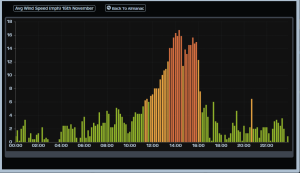
¡Buenos dias! An Oceansat satellite pass around midnight measured 15-20 knot WNW winds near Cerralvo as Pacific high pressure began building into BCS. Model forecasts are in excellent agreement that the WNW background flow will gradually become more northerly by mid-afternoon today, and with only a few high clouds expected, our local thermal should be able to pull the winds onshore. The surface pressure gradient will continue to tighten on Monday as high pressure builds into the western U.S., with borderline norte condtions likely developing here with the usual gusty N to NNW winds and increasing swell. The remainder of the forecast looks to be on track, as surface high pressure to our north will keep a solid north flow going through at least Thursday. At this point it appears that we still may have just enough north background wind on Friday for one more rideable day, but Saturday looks to be a down day as surface low pressure develops far to our north.
- Today…Mostly sunny. North wind 16-20 mph.
- Monday…Mostly sunny. North wind 20-24 mph and gusty.
- Tuesday…Sunny. North wind 18-22 mph.
- Wednesday…Mostly sunny. North wind 18-22 mph.
- Thursday…Mostly sunny. North wind 16-20 mph.
- Friday…Sunny. North wind 16-18 mph.
- Saturday…Sunny. Northeast wind 8-10 mph.