¡Buenos dias! Polar-orbiting satellites measured light WNW winds over the Sea of Cortez near Cerralvo last evening, verifying model forecasts of a weak background flow. The forecast has remained virtually unchanged, as a strong mid and upper-level low pressure system west of the Baja Peninsula this morning (see nerd note below) will move eastward over the next several days. The very weak surface pressure gradient and resulting light background wind we see this morning over BCS will last through at least Thursday. Abundant cloud cover will again be the rule today as moisture circulating around the low to our west overspreads our region. As the low draws closer on Thursday, models continue to show the chance for rain increasing. Although surface high pressure will build into the interior west of the U.S. on Friday and tighten the surface pressure gradient over BCS, residual low level moisture will likely lead to significant low clouds and even some light showers, with our local thermal significantly dampened. Model forecasts are in excellent agreement that the bulk of the cloud shield will finally move off to our east on Saturday, and with ample north background flow we should see a windy afternoon. Long-range model forecasts show a reinflorcing surface high is then forecast to build into the western U.S. on Sunday and give us solid north background flow into next week.
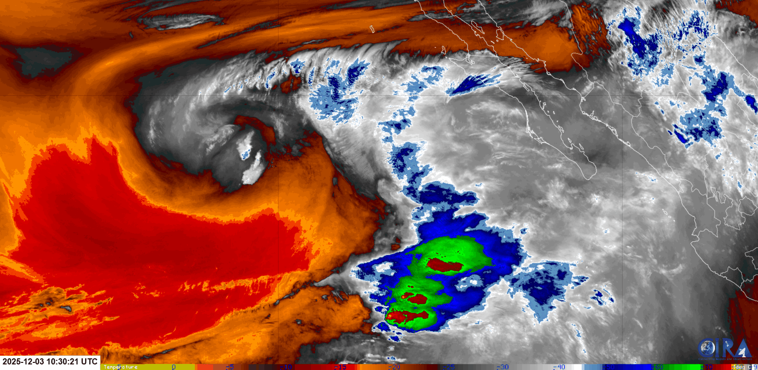
Nerd Note: Modern satellites have the capability to measure water vapor content in multiple layers of the atmosphere. As an example, here is an early morning loop from the NOAA GOES 18 satellite's mid-level moisture sensor.
Red shades are dry, white to blue shades show abundant moisture, and the red and yellow areas are likely thunderstorms.
Note the very distinctive counter-clockwise circulation west of the Baja Peninsula, and the moisture being drawn up from the southwest over the Baja Peninsula. This is what models are showing will move eastward and likely bring rain to our region Thursday into Friday.
- Today…Mostly cloudy with a few sprinkles possible late. Northeast wind 8-10 mph.
- Thursday…Cloudy with rain likely. North wind 8-10 mph.
- Friday…Mostly cloudy with showers likely. North wind 12-14 mph.
- Saturday…Mostly sunny. North wind 18-22 mph.
- Sunday…Sunny. North wind 18-22 mph.
- Monday…Mostly sunny. North wind 16-20 mph.
- Tuesday…Sunny. North wind 16-18 mph.