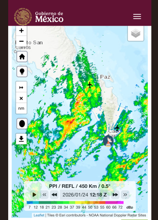
¡Buenos dias! Radar loops from Cabo San Lucas early this morning showed the main band of rain was moving through our area, and all of the latest model forecasts show the rain ending by mid-morning and skies clearing this afternoon. Surface low pressure centered over the northern Baja Peninsula early this morning will move eastward today, and circulation around this system will keep our background flow westerly. Surface high pressure will begin to build into BCS on Sunday, and with sunny skies we should see rideable winds during the afternoon. The surface pressure gradient is forecast to tighten on Monday, with north background flow increasing. There will be some high clouds on Monday, but we should see enough thin spots in the cloud cover to allow for at least a partial thermal boost. Model forecasts are in good agreement that the surface high centered far to our north will remain nearly stationary for the remainder of the week, with ample north flow continuing. High clouds will be the main variable Tuesday through Friday, but at this point it looks like we will see some filtered sunshine each day to help trigger our local thermal.
- Today…Cloudy with showers this morning, then becoming mostly sunny. Southwest to west wind 5-10 mph.
- Sunday…Sunny. North wind 16-18 mph.
- Monday…Mostly sunny. North wind 20-24 mph.
- Tuesday…Mostly sunny. North wind 18-22 mph.
- Wednesday…Mostly sunny. North wind 18-22 mph.
- Thursday…Mostly sunny. North wind 16-20 mph.
- Friday…Mostly sunny. North wind 16-20 mph.