¡Buenos dias! A pass by one of the polar orbiting satellites around midnight showed yesterday’s strong north background flow had decreased overnight, with 10 knot NW winds detected over the southern Sea of Cortez. Although the background flow will be substantially less today, several model forecasts do show just enough remaining to help jump-start our local wind machine. A band of high clouds over us this morning will quickly move eastward and leave full sunshine by midday, so we’ll also get a substantial thermal boost this afternoon. Surface high pressure centered over the Pacific Northwest of the U.S. today will build southeastward on Tuesday, with the surface pressure gradient tightening over BCS and north flow increasing. Some thin, high clouds may stream over from time to time, but enough filtered sunshine should make it through to give us a good thermal boost as well. The surface high will then move rapidly southeastward into western Texas on Wednesday and maintain a solid north background flow over our region. Model forecasts are in excellent agreement that the background flow will then rapidly weaken on Thursday, with summerlike onshore breezes expected both Thursday and Friday. A new surface high is then forecast to build into the 4-corners region of the U.S. just in time for the weekend, with solid north background flow returning on Saturday and continuing through at least Sunday.
- Today…Some morning high clouds, then becoming sunny. North wind 16-18 mph.
- Tuesday…Mostly sunny. North wind 20-24 mph.
- Wednesday…Sunny. North wind 16-20 mph.
- Thursday…Sunny. East wind 8-10 mph.
- Friday…Sunny. East wind 8-10 mph.
- Saturday…Sunny. North wind 16-18 mph.
- Sunday…Sunny. North wind 16-20 mph.
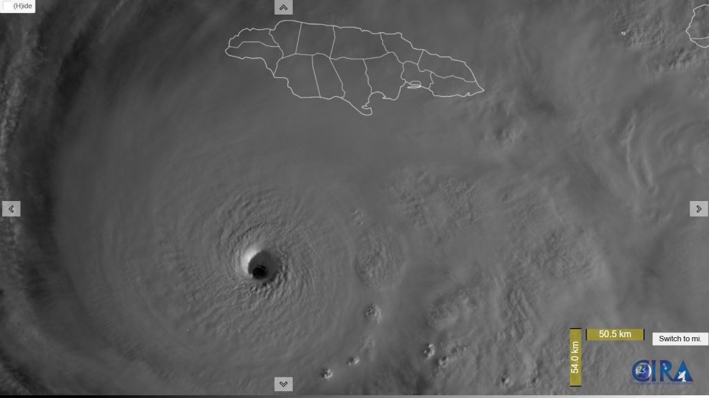
Nerd Note: A potentially catastrophic event is unfolding for the island nation of Jamaica, as a hurricane hunter aircraft early this morning showed hurricane Mellisa has become a category 5 storm with sustained winds of 160 mph. The storm is expected to make landfall on the southernwestern coast of Jamaica tonight. Here is a visible satellite image from just after sunrise showing the dark, clear eye, and sunlight reflecting off the western eyewall showing the spectacular stadium effect as the eyewall flares outward with height.