¡Buenos dias! A couple of satellite passes late last evening measured light and variable winds over the Sea of Cortez just east of Cerralvo. Today’s forecast is a low-confidence one, as the latest model forecasts show the background flow will be near or just below the lower threshold for fully activating our wind machine. Several of the more reliable models do show just enough north flow this afternoon, and with full sunshine returning, there is some room to be optimistic for marginally kiteable wind this afternoon, particularly on the northern beaches. The remainder of the forecast looks on track, with solid north flow returning on Saturday and lasting at least through Monday. Tuesday will see weaker north flow, but we may get one more windy day before we enter into a weak wind regime on Wednesday.
¡Buenos dias! A Haiyang satellite pass around midnight measured NW winds around 10 knots over the Sea of Cortez just east of Cerralvo, and all of the most recent numerical model forecasts show similar north background flow will continue today. While it now appears that the background flow will be sufficient to trigger our wind machine today, the big wild card will be the thickness of high cloud cover. Infrared satellite loops early this morning showed an area of clearing over our area, but another patch of thick high clouds was lurking to the southwest and most model forecasts bring it close to or over us this afternoon. That said, there are some indications that some of the models are over-forecasting the extent of the high clouds, so I’ll be optimistic and forecast just enough sun to bring us at least a partial thermal boost this afternoon. Friday will be a close call as well, as several of the latest models now show the background north flow increasing a bit during the afternoon and full sunshine returning, so I’ll keep the positive vibes going and call for another kiteable day. The remainder of the forecast looks on track, as surface high pressure centered over northern Utah will remain locked in place from Saturday through Monday and bring ample north background flow to our region. While we will see periods of high clouds, there should be enough breaks in the cloud cover to allow for at least partial thermal boosts each day. The surface high is forecast to weaken on Tuesday, but just enough north flow should remain to couple with full sunshine and give us another windy afternoon. Long-range models forecasts are in good agreement that the surface pressure gradient will become very weak by next Wednesday, with only light onshore breezes expected.
¡Buenos dias! An ASCAT satellite pass late last evening measured light and variable winds over the southern Sea of Cortez, but the latest model forecasts all show solid north background flow returning to our area this afternoon. Infrared satellite loops indicated clear skies over BCS, and with a sunny day ahead we will see our local thermal in fine form. The ridge of high pressure over the southwestern U.S. is forecast to weaken on Thursday, and with some high clouds moving in, we may see marginal winds at best. Surface high pressure will build into the western U.S. on Friday, but the models have again flipped, and now delay the onset of substantial north flow until Saturday. High pressure will remain locked in place over northern Utah through the upcoming weekend and into Monday, with ample north background flow expected. While there will likely be periods of high clouds Saturday through Monday, we should see enough filtered sunshine each day to give us at least a partial thermal boost. The surface high far to our north is then forecast to weaken on Tuesday, with north flow over BCS decreasing.
Nestled along the main road in La Ventana, right where the Thursday farmers market takes place, you’ll find Mariscos El Palmar — but the way it got there was less traditional than you might expect. 🐠🫧
The owner, Salvador, never actually planned to become a restaurateur. With a background in construction and architecture, his culinary journey began during the pandemic when he started bringing food he made at home in La Paz to his construction workers in La Ventana. When this simple operation blossomed into a business opportunity that Salvador couldn’t ignore, he decided to open Mariscos El Palmar as a food truck in March 2021. That has now grown into a spacious restaurant beneath a lovely palapa. After a forced relocation and some help from his friend Poncho Navarro of Ventana Blue, Salvador found this ocean vista spot.
Salvador’s mother’s influence is clear in El Palmar’s menu — especially with the signature ceviche, crafted from her recipe. “She’s the one who taught me how to make it,” he shares with a smile. “In the beginning, she made it, but once the business took off, she showed me how.” Salvador proudly recommends that ceviche, but he’ll tell you that his true favorite is the fish tacos. “I could eat them every day. I do,” he chuckles. Many friends and family members have joined him in this culinary adventure, helping to create a space where every guest feels at home. The restaurant is also a great option for private events and participates in many of the community’s festivals.
Reflecting on his journey, Salvador admits, “It’s been a love-hate relationship.” The leap from construction to cooking pushed him out of his comfort zone, but it also sparked a passion within him, showcasing the determination that has driven his success. Come by and enjoy the warmth and flavors that Salvador and his team have to offer!
⏰: Open everyday in the winter from 1pm – 9pm, and 1pm-8pm in the summer
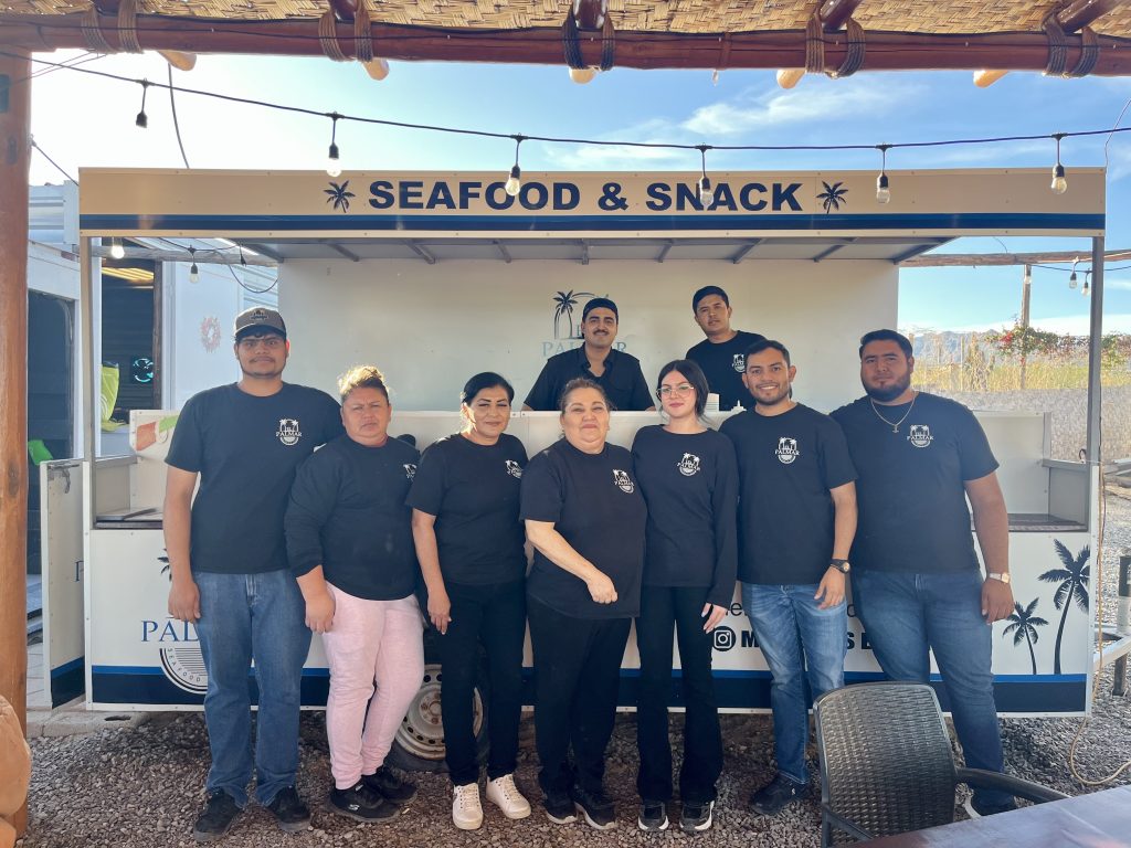
📸: Left to right:Rodolfo, Adriana, Cecilia, Mireya, sol, Salvador y Abel, back row:Paul y Alejandro
📸: Left to right: Rodolfo, Adriana, Cecilia, Mireya, sol, Salvador y Abel, back row: Paul y Alejandro
Español
Enclavado en la carretera principal de La Ventana, justo donde se celebra el mercado agrícola de los jueves, se encuentra Mariscos El Palmar, pero la forma en que llegó hasta allí fue menos tradicional de lo que cabría esperar. 🐠🫧
El propietario, Salvador, nunca pensó en dedicarse a la restauración. Con formación en construcción y arquitectura, su andadura culinaria empezó durante la pandemia, cuando empezó a llevar comida que hacía en su casa de La Paz a sus obreros de la construcción en La Ventana. Cuando esta sencilla operación floreció hasta convertirse en una oportunidad de negocio que Salvador no podía ignorar, decidió abrir Mariscos El Palmar como food truck en marzo de 2021. Ahora se ha convertido en un espacioso restaurante bajo una preciosa palapa. Tras un traslado forzoso y la ayuda de su amigo Poncho Navarro, de Ventana Blue, Salvador encontró este lugar con vistas al océano.
La influencia de la madre de Salvador es evidente en el menú de El Palmar, especialmente en el ceviche, elaborado con su receta. “Ella es la que me enseñó a hacerlo,” dice con una sonrisa. “Al principio lo hacía ella, pero cuando el negocio despegó, me enseñó a hacerlo ella.” Salvador recomienda con orgullo ese ceviche, pero le dirá que su verdadero favorito son los tacos de pescado. “Podría comerlos todos los días. Lo hago,” ríe entre dientes. Muchos amigos y familiares se han unido a él en esta aventura culinaria, ayudando a crear un espacio donde cada comensal se siente como en casa. El restaurante es también una gran opción para eventos privados y participa en muchas de las fiestas de la comunidad.
Reflexionando sobre su trayectoria, Salvador admite: “Ha sido una relación de amor-odio.” El salto de la construcción a la cocina le sacó de su zona de confort, pero también despertó en él una pasión que demuestra la determinación que ha impulsado su éxito. Ven y disfruta de la calidez y los sabores que Salvador y su equipo te ofrecen.
⏰:Todos los dias a la 1pm – 9pm en invierno, en verano de 12pm-8pm
📸: Rodolfo, Adriana, Cecilia, Mireya, sol, Salvador y Abel, En la parte de arriba Paul y Alejandro
¡Buenos dias! A Haiyang satellite pass early this morning measured SW winds of around 5 knots over the Sea of Cortez just east of Cerralvo, and model forecasts all show light background flow will continue today. Infrared satellite loops early this morning showed some relatively thin, high clouds streaming in from the southwest, but we should see plenty of sunshine as well this afternoon, with a light onshore breeze developing. A narrow ridge of high pressure will move into the southwestern U.S. on Wednesday and send a fresh pulse of north flow down the Sea of Cortez, and with full sunshine forecast to return, we will likely see a windy afternoon. The surface pressure gradient is forecast to weaken on Thursday, and depending on the thickness of high cloud cover, it looks like we could see a marginal day. Models are flip-flopping on the forecast for Friday, with the majority of the latest runs now showing surface high pressure building into the interior west of the U.S. and north background flow increasing over our area. Models are also showing a return of full sunshine on Friday, so at this point it looks like we should see a kiteable day. Long-range models are in good agreement that surface high pressure will remain anchored far to our north from Saturday through Monday, with ample north flow over BCS. The big wild card for Saturday through Monday will be the thickness of high cloud cover, but for now it looks like we will see enough filtered sunshine each day to trigger our local thermal.
¡Buenos dias! An Oceansat satellite pass around midnight measured 15 knot winds just east of Cerralvo, but all of the latest numerical model runs continue to insist that the ample north background flow we’ve enjoyed lately will rapidly weaken this morning and fall to levels just below what would normally trigger our local wind machine (see nerd note below). Another potential negative for today will be patches of high clouds which may at times partially dampen our local thermal. That said, it’ll be close…and I wouldn’t be surprised to see a couple hours of kiteable wind this afternoon especially on the northern beaches. Models are in excellent agreement that an E-W oriented trough of low pressure will linger over the southwestern U.S. on Tuesday, with very light background flow over BCS. Surface high pressure will build back into the interior west of the U.S. on Wednesday and send a fresh pulse of north flow into the southern Sea of Cortez, and with full sunshine returning, we should see a good thermal boost as well. Thursday will be another nail-biter, as model forecasts show the background flow weakening and patchy high clouds moving in. Surface high pressure will begin building into the western U.S. on Friday, but it now appears that we’ll have to wait one more day for the next surge of north flow. The upcoming weekend looks good at this point, with ample north flow and only some thin patches of high clouds at times.
Today…Mostly sunny. Northeast wind 10-12 mph.
Tuesday…Sunny. East wind 8-10 mph.
Wednesday…Sunny. North wind 18-22 mph.
Thursday…Mostly sunny. North wind 14-16 mph.
Friday…Sunny. East wind 8-10 mph.
Saturday…Mostly sunny. North wind 18-22 mph.
Sunday…Mostly sunny. North wind 16-20 mph.
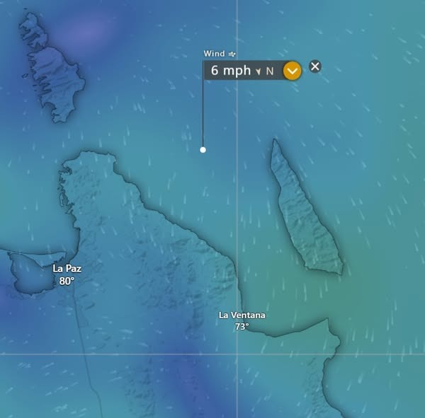
Nerd note: Several of you have asked about the minimum threshold of north background flow I use as part of the forecast process. I typically look at a point about halfway between the northern tip of Cerralvo and the Cacachilas Mountains (see graphic). If the model forecast background flow is at least 7 mph, AND we are expecting sunny skies, then it will likely be a go day. That said, there are at least 6 numerical models I look at, and they can vary substantially in their forecasts. If there is a general consensus, then it lends more confidence to the forecast. For example in the graphic below, today’s model forecasts all show the background flow below 7 mph, so it’s more likely that it’ll be a down day. In addition, infrared satellite loops and model forecasts show some patches of relatively thin, high cloud that could partially dampen our local thermal. Place your bets…
¡Buenos dias! Multiple satellite passes missed the southern Sea of Cortez last evening, but all of the most recent numerical model forecasts show moderate to strong north background flow will continue today. Surface high pressure centered just north of the 4-corners area of the U.S. this morning will begin to rapidly weaken this evening and by Monday all of the latest model runs show the background north flow falling below the minimum threshold to trigger our wind machine. The models are in good agreement that an area of low pressure will form over the southwestern U.S. on Tuesday, with winds over BCS remaining light. A ridge of high pressure is then forecast to build into the southwestern U.S. on Wednesday, with solid north flow returning to our region. The pulse of north flow will be short-lived however, as Thursday will likely be a marginal day with the background north flow forecast to weaken and hover right around the go/no go speed. Long-range model forecasts are in good agreement that surface high pressure will build into the western U.S. on Friday, with moderate north flow returning to BCS. The high will likely remain nearly stationary through the following weekend, and with sunny skies expected, we should see a great stretch of windy days.
¡Buenos dias! An Oceansat satellite pass around midnight measured 10 knot WNW winds over the Sea of Cortez just east of Cerralvo, but all of the latest numerical model runs show surface high pressure will build into the interior west of the U.S. today, with the background flow over BCS becoming more northerly and increasing substantially this afternoon. Moderate to strong north flow is forecast to continue over our region on Sunday, and with sunny skies expected, we should see an added thermal boost as well. Models are in good agreement that the surface high far to our north will rapidly weaken on Monday, with north flow decreasing to near or below the lower threshold to trigger our local wind machine. At this point I’ll be optimistic and say we will have just enough remaining north background flow to combine with a mostly sunny afternoon and give us rideable conditions. A trough of low pressure is forecast to spread across the southwestern U.S. on Tuesday, and this will create very light background flow over BCS, with only light onshore flow expected here. Surface high pressure is forecast to build back into the interior west of the U.S. on Wednesday, with increasing north flow over our area. Long-range model forecasts differ substantially, but some show just enough north background flow remaining to help trigger our wind machine into next Friday…stay tuned.
Today…Mostly sunny. North wind 20-24 mph and gusty.
¡Buenos dias! Several satellite passes late last evening into the early morning measured 10 knot NW winds over the Sea of Cortez just east of Cerralvo, and those measurements correlate well with the latest numerical model forecasts which predict similar wind speeds for today. Infrared satellite loops early this morning showed only a few thin, high clouds in our area, so we will see another good thermal boost this afternoon. Model forecasts continue to be in excellent agreement that surface high pressure will build into the western U.S. on Saturday and cause the surface pressure gradient to tighten over BCS. Low-end norte conditions are likely on Saturday with the usual gusty winds, particularly on the northern beaches. The norte should ease a bit on Sunday but model forecasts show solid north flow will continue as surface high pressure remains centered near the 4-corners area of U.S. Monday will see the background flow quickly weaken as models show a rapid transition to low pressure over the southwestern U.S. Light winds are expected on Tuesday as the trough of low pressure lingers to our north, then we will likely see a return of solid north flow on Wednesday…possibly lasting into next Thursday.
Today…Sunny. North wind 16-20 mph.
Saturday…Mostly sunny. North wind 20-24 mph and gusty.
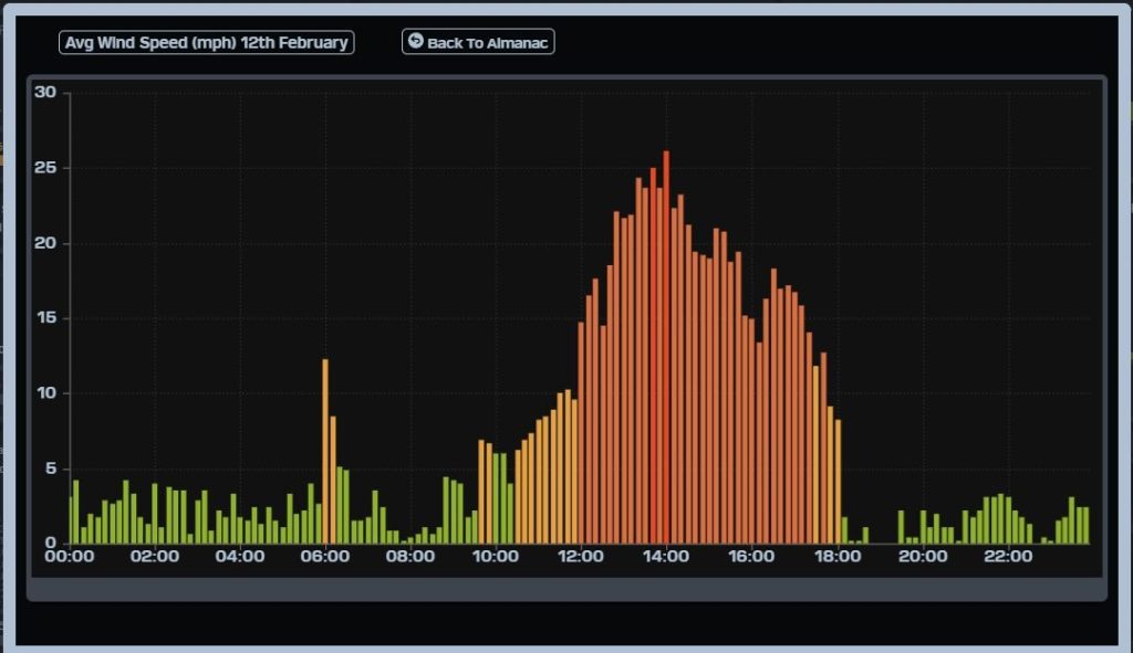
¡Buenos dias! Wow!! For a time yesterday’s superthermal significantly exceeded my forecast of 16-20 mph. The gauge at the campground showed that while the 10 minute average wind speed was close for much of the afternoon, with winds of 18-22 mph from 12:30-3:30, a big surge occurred from around 1:20-2:00 pm with sustained winds reaching 24-26 mph and gusts up to 33 mph (see graph below). A series of scatterometer satellite passes measured 10-15 knot winds over the southern Sea of Cortez around midnight., and all of the latest model forecasts show solid north background flow will continue today. While we may not see another superthermal, infrared satellite loops early this morning showed another sunny day ahead, so our local thermal will likely be in peak form. Model forecasts are in excellent agreement that the wind party will continue into the upcoming weekend, as surface high pressure builds into the interior west of the U.S. and the surface pressure gradient tightens over BCS. While we may not see norte conditions with strong winds continuing overnight, sustained winds may reach into the mid 20 range both Saturday and Sunday during the afternoon. There will likely be some thin, high cloud cover at times, but we should see ample filtered sun to give us an added thermal boost as well. The background flow will weaken some by Monday, but enough should remain to give us another windy afternoon. Surface low pressure is forecast to form over the southwestern U.S. on Tuesday, with our background flow becoming light. The down time will likely be short, as long-range model forecasts show surface high pressure building back into the western U.S. on Wednesday with another surge of north flow reaching BCS.
Today…Sunny. North wind 18-22 mph. Friday…Sunny. North wind 18-22 mph. Saturday…Mostly sunny. North wind 20-24 mph. Sunday…Mostly sunny. North wind 20-24 mph. Monday…Mostly sunny. North wind 16-18 mph. Tuesday…Mostly sunny. East wind 8-10 mph. Wednesday…Mostly sunny. North wind 18-22 mph.