La Ventana Stories

Wind – January 12, 2026

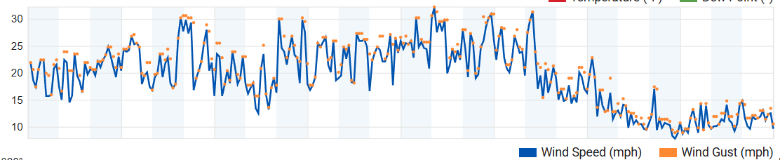
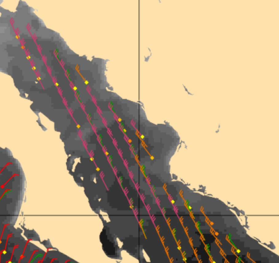
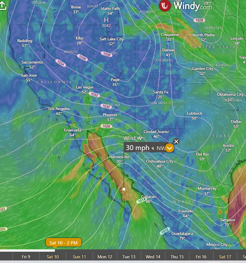
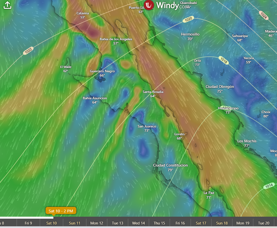
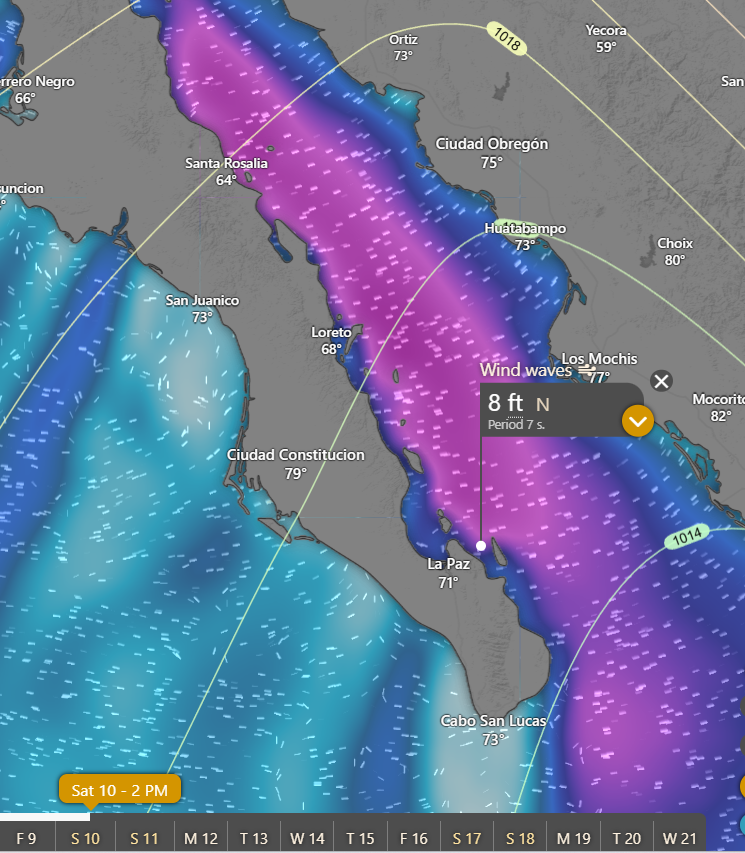
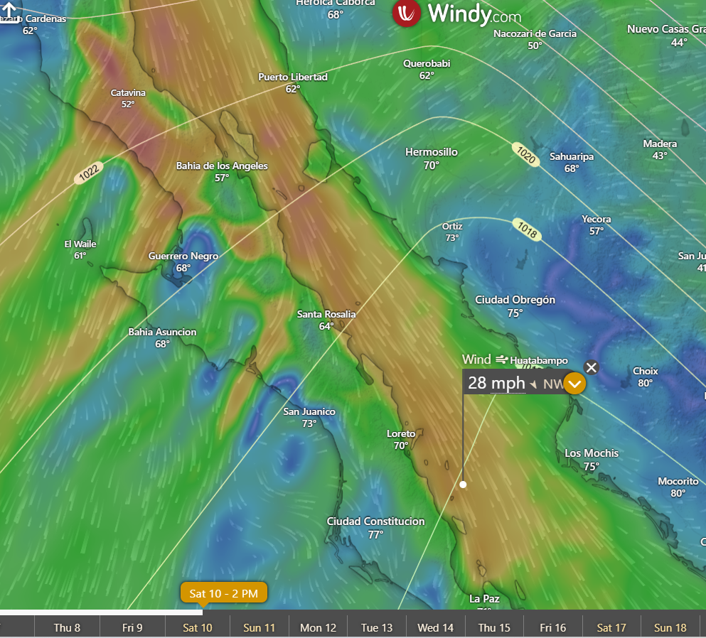
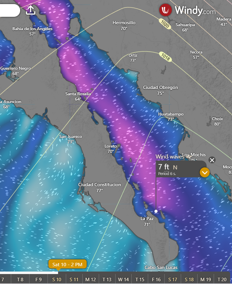
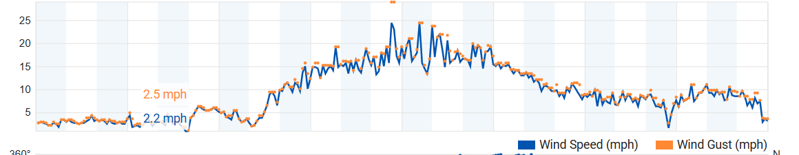
¡Buenos dias! While there was still some wind-shadowing at times on the northern beaches, the wind quality improved yesterday and gauges at both Rasta and the campground showed sustained winds peaked in the lower 20s with gusts well into the mid 20 mph range. An Oceansat satellite pass just before midnight last night measured NNW winds of 20 knots near Cerralvo, with 25 to 30 knot winds from near Loreto northward through the remainder of the Sea of Cortez. The strong surface high pressure system that brought us the norte remained centered near Salt Lake City this morning, and all of the recent model forecasts continue to show that it will remain essentially stationary through the upcoming weekend. Short-range model forecasts are in agreement that there will not be any significant west component to the background flow this afternoon, and that should bring all area beaches good quality, steady winds. We'll likely see a bump up in the background flow tomorrow, and with sunny skies expected, we should see a good thermal boost as well. While the surface high centered far to our north will remain locked in place, it will begin to slowly weaken on Thursday, but at this point the majority of models show ample north background flow continuing over our region through the weekend. Some thin, high clouds will likely begin to creep in from the southwest on Wednesday and last through the weekend, but at this point it looks like there will still be plenty of sunshine each day.

(Tides)
  • Today…Sunny. North wind 18-22 mph.
  • Tuesday…Sunny. North wind 20-24 mph.
  • Wednesday…Mostly sunny. North wind 20-24 mph.
  • Thursday…Mostly sunny. North wind 18-22 mph.
  • Friday…Mostly sunny. North wind 16-20 mph.
  • Saturday…Mostly sunny. North wind 16-20 mph.
  • Sunday…Mostly sunny. North wind 16-20 mph.

Wind – January 11, 2026

¡Buenos dias! Gusty didn’t fully describe the winds yesterday (see graphic from Rasta Beach below), as the wind gauges at both Rasta Beach and the campground showed extremely variable winds, with sustained winds at times down into the mid to upper teens but gusts still near 30 mph. The top gusts (usually a 3-10 second average) recorded were in the low to mid 30s. There is a wind sensor on the roof of Club Cerralvo, which is probably 40-60 feet above the ground, and it measured sustained winds of 37 mph with a gust to 46 mph…thanks for that observations JS. A pass by one of the ASCAT satelllites last evening measured 20 knot NNW winds near Cerralvo, with 30 knot winds common about 100 miles to the north. The norte should ease a bit today, as model forecasts are in good agreement that the background flow will not be quite as strong nor as wildly gusty as yesterday. The significant west component noted at times yesterday at area gauges should be less of an issue today, however northern beaches could still see some wind shadowing at times. The very large swell will only slowly subside today, as 30 knot winds still blowing across the central Sea of Cortez have created a long, large swell train. The latest round of model forecasts show the strong surface high pressure system centered near Salt Lake City this morning will be located in the same spot by next Saturday, and only minor day to day variations in wind speed are forecast through Thursday. A slight weakening of the background flow is expected Friday and Saturday as the surface high begins to weaken. This means the week ahead will be one of the windiest we’ve seen in a while, and with only a few thin, high clouds at times, I’m hopeful that (other than maybe today) our thermal will be able to pull most of any remaining west out of background flow.

(Tides)

  • Today…Sunny. North wind 20-24 mph.
  • Monday…Sunny. North wind 18-22 mph.
  • Tuesday…Sunny. North wind 20-24 mph.
  • Wednesday…Mostly sunny. North wind 20-24 mph.
  • Thursday…Mostly sunny. North wind 18-22 mph.
  • Friday…Sunny. North wind 16-20 mph.
  • Saturday…Mostly sunny. North wind 16-20 mph.

Wind – January 10, 2026

¡Buenos dias! Wind gauges yesterday recorded sustained winds in the low to mid 20s with gusts into the mid 30s as the strongest norte so far this season arrived. As is typical of the bigger nortes, strong wind gusts continued overnight even with a significant west component, with area gauges recording occasional gusts from the upper 20s into the mid 30s early this morning. A Haiyang satellite pass last evening measured 25 knot winds just east of Cerralvo, with solid 30 knot winds over the southern Sea of Cortez from just north of Cerralvo north-northwestward for several hundred miles (see nerd note below). Nearly all of the latest model forecasts continue to be in excellent agreement that the strong surface high centered near Salt Lake City this morning will remain locked in place through at least Thursday, and although norte conditions will likely ease tomorrow as the high weakens a bit, solid NNW background flow will very likely continue through at least Thursday. While there are some differences in the extended range forecasts, most are showing that we will continue to see ample north background flow through next weekend and possibly into the following week. There may be some thin, high clouds from time to time over the next week, especially on Wednesday and Thursday, but at this point it looks like there will be enough sunshine each day to trigger our local thermal.

Nerd Note: As noted above one of the polar-orbiting satellites recorded the current norte in all its glory last evening. These satellites use directed microwave and radar pulses to determine wind speeds to within about 5 mph. The graphic below shows 25 knot winds near Cerralvo, and 30 knot winds (3 barbs) from just north of Cerralvo to a point in the east-central Sea of Cortez…a distance of over 350 miles. This will likely generate large swell directed into La Ventana Bay today, and model forecasts are showing wave heights entering the northern bay of 8 feet. We don’t have any buoys nearby to measure wave heights, so I’d like to hear your observations. Of course please be safe entering and exiting the water today…there will likely be a big shore break at times.

(Tides)

  • Today…Sunny. North wind 22-26 mph and gusty.
  • Sunday…Sunny. North wind 20-24 mph.
  • Monday…Sunny. North wind 20-24 mph.
  • Tuesday…Sunny. North wind 20-24 mph.
  • Wednesday…Mostly sunny. North wind 18-22 mph.
  • Thursday…Mostly sunny. North wind 18-22 mph.
  • Friday…Sunny. North wind 16-20 mph.

Wind – January 9, 2026

¡Buenos dias! Norte conditions are working their way down the Sea of Cortez this morning, with observations early this morning at Punta Bufeo in central BC showing sustained winds in the low to mid 30s with gusts to 40 mph. Norte conditions will likely develop by mid afternoon in our region and peak on Saturday. A strong surface high will stay locked in place over the western U.S. through the upcoming week, with moderate to strong north background flow continuing through at least Wednesday. Winds should begin to diminish a bit on Thursday as the high to our north finally begins to weaken.

(Tides)
  • Today…Sunny. North wind increasing to 22-26 mph and gusty.
  • Saturday…Sunny. North wind 22-26 mph.
  • Sunday…Sunny. North wind 20-24 mph.
  • Monday…Sunny. North wind 20-24 mph.
  • Tuesday…Mostly sunny. North wind 20-24 mph.
  • Wednesday…Mostly sunny. North wind 20-24 mph.
  • Thursday…Mostly sunny. North wind 18-22 mph.

Wind – January 8, 2026

¡Buenos dias! Satellite-derived winds of 10-15 knots were noted just east of Cerralvo late last evening, and the latest batch of model forecasts show an E-W oriented ridge of high pressure over the central Baja Peninsula will lead to increasing background flow over our region this afternoon. Model forecasts are in good agreement that the thick cloud cover early this morning will thin by around midday, and mostly sunny skies should give us an added thermal boost this afternoon. The norte is still on track to arrive tomorrow and peak on Saturday as a strong surface high builds into the interior west of the U.S. and the surface pressure gradient over BCS tightens. Models are in excellent agreement that the high will then remain nearly stationary through at least Wednesday, and while norte conditions may ease on Sunday, we will likely see a stretch of very windy days into the middle of next week.

(Tides)
  • Today…High clouds this morning, then becoming mostly sunny. North wind 16-20 mph.
  • Friday…Sunny. North wind 22-26 mph and gusty.
  • Saturday…Mostly sunny. North wind 22-26 mph.
  • Sunday…Sunny. North wind 20-24 mph.
  • Monday…Mostly sunny. North wind 20-24 mph.
  • Tuesday…Mostly sunny. North wind 20-24 mph.
  • Wednesday…Sunny. North wind 18-22 mph.

Wind – January 7, 2026

¡Buenos dias! The forecast for today is a low-confidence one, as several factors will be in play that could make or break it. First, a surface low pressure system just offshore of the far northern Baja Peninsula will move eastward today spreading rain as far south as far northern BCS. As the low approaches, it will nudge a narrow ridge of high pressure located just to our north farther southward, and this will likely add a significant west component to the background flow by midday. As the low then continues eastward this afternoon, several of the models show the ridge of high pressure moving back northward and our background flow becoming more favorable (northerly) by mid afternoon. The second big variable today wil be cloud cover. Models show increasing high clouds this morning, possibly thick enough to put a significant dent in our local thermal. A couple of the models do show some thin spots in the high cloud cover this afternoon, and if this does come to pass we could get rideable winds later this afternoon. Cloud cover will again be the main variable for tomorrow, as several models show the northern edge of a band of thick high clouds will be very near us. For now I’ll be optimistic and hope we see some afternoon sun. The latest model forecasts are in excellent agreement that a strong surface high pressure system will build into the interior west of the U.S. on Friday into Saturday and bring classic norte conditions to our region (see nerd note below). As well as the typical strong, gusty winds of a norte, wave models are predicting large swell by Friday afternoon, with the swell likely peaking on Saturday. Long-range model forecasts are in excellent agreement as well, with the strong surface high parked over the western U.S. and only slowly weakening into the middle of next week.

Nerd Note: While we really haven’t seen a big norte yet this season, the model forecasts for Friday and Saturday are showing the classic setup for a big one. The graphic below shows the forecast for surface pressure and wind speed for Saturday. Note the strong surface high centered over northern Utah with the tightly spaced isobars over the Baja Peninsula. The second graphic is zoomed in over the Baja Peninsula. Note the NNE to SSW bands of high winds as the strong flow is pushed through the relatively narrow mountain passes over the peninsula. The third graphic is the ECMWF forecast for wind swell on Saturday. At this point the model is forecasting open ocean swell height of 8 feet coming into the bay between Cerralvo and the Cacachilas mountains.

(Tides)

  • Today…Increasing high clouds. North…northwest wind 16-18 mph possibly becoming north late.
  • Thursday…Partly sunny. North wind 16-18 mph.
  • Friday…Sunny. North wind 22-26 mph and gusty.
  • Saturday…Mostly sunny. North wind 22-26 mph.
  • Sunday…Sunny. North wind 20-24 mph.
  • Monday…Mostly sunny. North wind 20-24 mph.
  • Tuesday…Partly sunny. North wind 18-22 mph.

Wind – January 6, 2026

¡Buenos dias! An Oceansat satellite pass just before midnight measured 10-15 knot NNW winds over the Sea of Cortez near Cerralvo, and the latest batch of model forecasts show the background flow over our region will increase today. Infrared satellite loops early this morning showed clear skies over BCS, and the models are in good agreement that we will see lots of sunshine today to help drive our local thermal. Surface low pressure spinning just off the California coast this morning is forecast to drop southward today then move inland over the northern Baja Peninsula on Wednesday. As this happens, the ridge of high pressure to our north will be pushed southward closer to us, and as a result, the new model runs are showing a significant westerly component to the winds tomorrow. It’ll likely be a battle between the dreaded westerlies and our local thermal, but if we see enough sun tomorrow afternoon, the thermal could be just strong enough to pull the winds onshore. Thursday will likely see ample north background flow returning to BCS, but we may see thicker cloud cover as well that could at least partially dampen our thermal. For those that have been waiting all season for a big norte, you are in luck (see nerd note below) as models are in excellent agreement that a strong surface high pressure system will build into the interior west of the U.S. on Friday, then remain nearly stationary through at least Sunday. The norte may begin to slowly subside on Sunday, but with the surface high locked in place, we’ll likely see solid north flow continuing into next week.

Nerd Note: Several of the global models not only forecast atmospheric conditions, but also forecast ocean wave heights. They do this by complex, physics-based calculations, but 3 of the main ingredients are wind speed, fetch (the distance over which the wind blows), and the duration of the wind. Model forecasts for Saturday show very strong winds over the length of the Sea of Cortez, with a trajectory pointing right at us (see graphic below). The second graphic shows the ECMWF model forecast for wind waves, showing 7 foot swell coming into the north end of La Ventana Bay on Saturday afternoon.

(Tides)

  • Today…Sunny. North wind 18-22 mph.
  • Wednesday…Mostly sunny. North/northwest wind 16-18 mph.
  • Thursday…Partly sunny. North wind 16-18 mph.
  • Friday…Sunny. North wind 22-26 mph.
  • Saturday…Sunny. North wind 22-26 mph.
  • Sunday…Sunny. North wind 20-24 mph.
  • Monday…Sunny. North wind 18-22 mph.

Wind – January 5, 2026

¡Buenos dias! Patience paid off yesterday as the wind gauge at the campground showed a slow climb during the early afternoon, then a slight decrease in winds around 1:30 as a batch of high clouds moved in, then the resumption of a steady climb to a peak of 18-20 mph between 3 and 4:30 pm. An Oceansat satellite pass just after midnight confirmed model forecasts that the background flow had decreased a bit last evening, and while sufficient north wind is expected to continue today, the big issue will be cloud cover and how it will affect our local thermal. Early morning satellite loops showed extensive mid-level clouds over our region with more streaming in from the southwest. While confidence is low, model forecasts do show a glimmer of hope however, as just enough clearing may occur this afternoon to at least partially trigger our thermal. We should see a return of sunny to mostly sunny skies on Tuesday, and with the background flow increasing, it should be a windy afternoon. Some high clouds will again creep into the picture on Wednesday, but models are showing that they will likely be thin enough to allow filtered sunshine to activate our thermal once more. More extensive cloud cover may move in on Thursday, but at this point I'll be optimistic that we'll salvage a rideable day. The latest model forecast runs continue to be in excellent agreement that a strong surface high will build into the interior west of the U.S. on Friday and send a bona fide norte into BCS. At this point it looks like the norte will last through Saturday, then begin to fade on Sunday.

(Tides)
  • Today…Partly sunny. North wind 16-18 mph.
  • Tuesday…Sunny. North wind 18-22 mph.
  • Wednesday…Mostly sunny. North wind 16-20 mph.
  • Thursday…Partly sunny. North wind 16-18 mph.
  • Friday…Sunny. North wind 22-26 mph.
  • Saturday…Mostly sunny. North wind 22-26 mph.
  • Sunday…Mostly sunny. North wind 18-22 mph.

Wind – January 4, 2026

¡Buenos dias! The wind gauge at the campground peaked at 18-20 mph from around 12:30-2:30 yesterday afternoon, and the gauges at both northern and southern beaches showed much steadier wind as well. The going forecast looks to be on track, as the most recent forecast model runs show a ridge of high pressure will remain parked over the the northern or central Baja Peninsula through Thursday, with solid north background flow continuing over southern BCS. At this point it looks like our local thermal will be in fine form as well, with only a few high clouds at times…mostly on Monday. Long-range model forecasts are in good agreement that a strong surface high will build into the interior west of the U.S. on Friday into Saturday and bring at least low-end norte condtions to BCS.

(Tides)
  • Today…Sunny. North wind 18-22 mph.
  • Monday…Mostly sunny. North wind 16-20 mph.
  • Tuesday…Sunny. North wind 18-22 mph.
  • Wednesday…Sunny. North wind 18-22 mph.
  • Thursday…Sunny. North wind 16-20 mph.
  • Friday…Sunny. North wind 20-24 mph.
  • Saturday…Mostly sunny. North wind 20-24 mph.

Wind – January 3, 2026

¡Buenos dias! The wind gauge trace at Rasta Beach yesterday looked more like a seismograph during a major earthquake (see graph below) as a pronounced west component produced very inconsistent and gusty winds there. The gauge at the campground also showed a persistent west component with average 10 minute sustained winds in the 16-18 mph range with gusts well into the mid 20s. An Oceansat satellite pass just after midnight showed NW winds at 15 knots near Cerralvo, but the latest batch of model forecasts indicate that the background NW flow will gradually become more northerly this afternoon, and although northern beaches may still see gusty conditions at times, we should see better quality wind today. Surface high pressure centered over the 4-corners region of the U.S. early this morning will merge with a ridge of high pressure over the eastern Pacific on Sunday, creating an elongated ridge of high pressure extending from the Eastern Pacific to the northern Baja Peninsula and countinuing northeastward into Arizona. Model forecasts are in good agreement that this feature will remain nearly stationary through Thursday, with ample north background flow continuing for our region. Although some thin, high clouds will likely stream overhead from time to time this week, we should see enough sun each day to trigger our local thermal. Long-range model forecasts are in excellent agreement that a strong surface high just west of California will build eastward into the interior west of the U.S. on Friday and begin to tighten the surface pressure gradient over BCS with increasing north flow here.

(Tides)

  • Today…Sunny. North wind 18-22 mph.
  • Sunday…Mostly sunny. North wind 18-22 mph.
  • Monday…Mostly sunny. North wind 16-20 mph.
  • Tuesday…Sunny. North wind 18-22 mph.
  • Wednesday…Mostly sunny. North wind 18-22 mph.
  • Thursday…Mostly sunny. North wind 16-20 mph.
  • Friday…Mostly sunny. North wind 18-22 mph.