¡Buenos dias! An ASCAT satellite pass last evening measured W to NW winds of around 5 knots over the Sea of Cortez just east of Cerralvo. All of the most recent numerical model runs show a light wind regime over BCS today and lasting through Monday. There is some hope to see a pulse of north flow next Tuesday.
¡Buenos dias! An Oceansat satellite pass just after midnight confirmed that the norte has died, as it measured NNW winds of around 10 knots over the Sea of Cortez just east of Cerralvo. The vast majority of model forecasts show we will see sufficient background north flow remaining today to help jump-start our local wind machine. Infrared satellite loops early this morning showed another sunny day ahead, so we will also see a good thermal boost. Models continue to show a light wind regime setting in on Wednesday and lasting into next week. Extended-range model forecasts do show hope for a return of some north flow during the middle of next week.
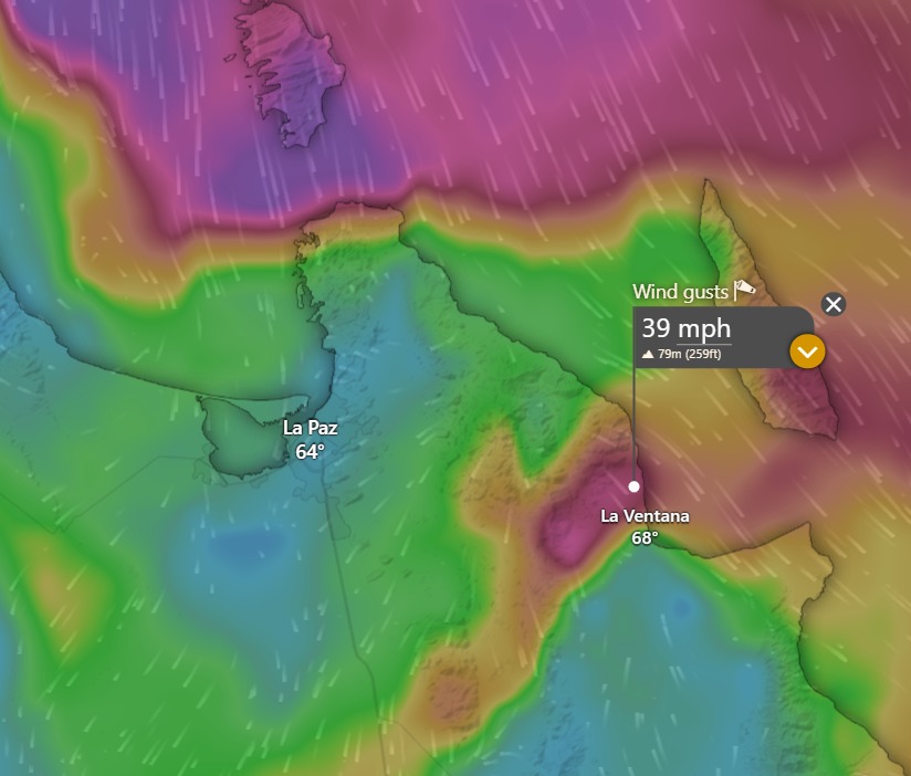
¡Buenos dias! The mountain wave that the HRRR model forecast yesterday did indeed materialize overnight. The highest gust I have seen was 53 mph at Club Cerralvo at 4:39 am, with more sheltered locations right along the beach gusting in the mid 30s. The local mountain wave gusts will diminish this morning and the more widespread norte will also ease up a bit this afternoon. That said, we’ll still see strong to moderate NNW background flow continuing this afternoon, and our local thermal should pull much of the west out of the background flow, especially on southern beaches. Northern beaches will likely continue to see some wind-shadowing and gusty conditions this afternoon. Models are in good agreement that we will see a more typical La Ventana pure thermal day on Tuesday, with good quality side-onshore winds. A light wind regime will then take hold on Wednesday and last through at least Sunday with only light onshore breezes each afternoon.
Today…Sunny. Northwest winds gusting to 40 mph early this morning, then becoming north…northwest to north at 20-24 mph.
¡Buenos dias! Well, yesterday was really wierd. Even though an afternoon satellite pass confirmed model forecasts of 15 knot north background flow coming into the bay, and we had a nearly cloudless sky, our local thermal was a virtual no show as 10 minute sustained winds at the campground only peaked at 16-18 mph. I don’t have an explanation for why we didn’t see much stronger winds yesterday…sometimes the atmosphere will still throw a real curve ball! A satellite pass late last evening confirmed that the norte has arrived, with 20-25 knot winds measured from Mulege southward to the East Cape. With such strong background flow, our local thermal usually doesn’t add much to the windspeed, but it will likely pull much of the west component out of the wind by this afternoon. That said, northern beaches may see some wind-shadowing as the wind direction remains nearly due north. Models show the norte peaking tonight (see nerd note below) then gradually subsiding on Monday. Several model forecasts are showing just enough north flow remaining on Tuesday to help trigger our local wind machine and bring us one more rideable afternoon before a long stretch of light wind days starts Wednesday…possibly lasting into early next week.
Today…Sunny. North wind 22-26 mph and gusty.
Monday…Sunny. North wind 20-24 mph.
Tuesday…Sunny. North wind 16-18 mph.
Wednesday…Sunny. East wind 8-10 mph.
Thursday…Sunny. East wind 8-10 mph.
Friday…Sunny. East wind 8-10 mph.
Saturday…Sunny. East wind 8-10 mph.
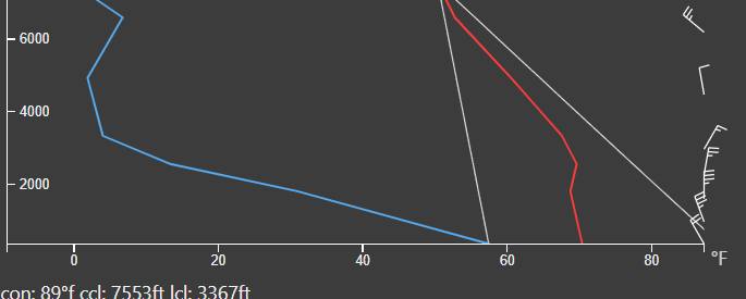
Nerd Note: Model forecasts are in good agreement that the norte will peak tonight, with NNW background flow just north of the bay of around 25 knots. An interesting phenomena is forecast to occur by the HRRR model, which has a 3 km resolution with the ability to resolve much smaller scale features than the global models like the ECMWF and GFS. As the strong norte winds approach the Cacachilas Mountains, they bank up against that barrier and the wind speed slows significantly as the flow is forced up and over the mountain barrier. The model also shows a nearly constant temperature with height up through around 4000 feet (see the red line in the second graphic), which is very stable so as the air is forced up over the mountains, it cools and becomes much ‘heavier’ than the surrounding relatively warm atmosphere. The air then sinks rapidly on the lee side of the Cacachilas Mountains and accelerates into what is called a mountain wave wind. The HRRR model is forecasting wind gusts of nearly 40 mph tonight particularly in areas just downslope of the mountains (El Sargento).
¡Buenos dias! A satellite pass late last evening measured 15 knot NW winds over the Sea of Cortez just east of Cerralvo, with 20 knot NW winds farther east over the central Sea of Cortez. Surface analysis this morning showed a large ridge of high pressure extending from the northern Rocky Mountains westward to the Pacific Northwest of the U.S. This feature has caused the surface pressure gradient to tighten over the Baja Peninsula, and the latest model forecasts show the ridge sinking southward today with solid north background flow over BCS. Model forecasts continue to be in excellent agreement that as this feature continues to sink southward on Sunday, the surface pressure gradient will tighten even more over the southern Sea of Cortez, with norte conditions expected here. The norte is forecast to subside on Monday, but with moderate background flow and another sunny day, we will likely see our local wind machine in fine form. As the surface pressure gradient weakens further on Tuesday, the background north flow will continue to subside, but a couple of the models do show just enough for perhaps one more windy afternoon. Long-range model forecasts are in excellent agreement that a summer-like light wind pattern will set up on Wednesday and continue for several days.
¡Buenos dias! The latest model forecasts continue to be on track with NW background flow becoming more northerly this afternoon, and infrared satellite loops early this morning showed another sunny day ahead with a big thermal boost likely. Winds are forecast to increase on Saturday into Sunday as surface high pressure builds into the western U.S., with norte conditions expected on Sunday. Winds will decrease on Monday but a couple of the long-range model forecasts show just enough north flow lasting into Tuesday. A light wind regime continues to look likely from Wednesday through the remainder of next week.
¡Buenos dias! The wind yesterday was substantially less than I forecast, with winds languishing in the 12-14 mph range, then finally peaking from 2-3:30 at around 15-18 mph at the campground and 18-20 mph at Rasta. As opposed to yesterday, today’s model forecasts are unanimous that there will be sufficient north background flow to help trigger our wind machine. Infrared satellite images early this morning showed another sunny day ahead, so a solid thermal boost is likely this afternoon. The forecast reasoning remains intact for the rest of the upcoming week, as models are in unusually good agreement that we will see ample north background flow again on Friday, then as surface high pressure builds into the western U.S., the pressure gradient will tighten over BCS with winds increasing on Saturday. Norte conditions look likely on Sunday before diminishing on Monday. Just enough north flow may remain on Tuesday to give us one more rideable day before a light wind regime takes shape over BCS. Extended range models show light winds may then last for almost a week.
¡Buenos dias! Late-evening satellite passes measured generally west winds of 5-10 knots over the Sea of Cortez, however the majority of model forecasts show the background flow becoming more northerly this afternoon. Infrared satellite loops early this morning showed a few narrow bands of thin, high clouds but model forecasts indicate a sunny afternoon ahead so we should see a sizable thermal boost. Similar conditions are forecast to persist through Friday as a ridge of high pressure extending eastward from the Pacific over BCS supplies ample NW to N background flow and strong April sun triggers solid afternoon thermals each day. The latest global models continue to be in good agreement that a large ridge of high pressure along the Canada/U.S. border on Friday will sink southward to a position from Wyoming to Oregon on Saturday, then farther south into the southwestern U.S. on Sunday. This will set the stage for a late-season norte here, with winds increasing on Saturday and full-on norte conditions looking likely for Sunday. Long-range model forecasts show the norte subsiding a bit on Monday, with sufficient north background flow maybe continuing into Tuesday.
¡Buenos dias! We scored yesterday as the wind gauge at the campground measured 10-minute sustained winds of 20-24 mph from 11 am until around 4 pm. Today will not be a repeat, as although northwest winds of 10 knots were measured near Cerralvo last evening by an Oceansat satellite pass, all of the latest batch of numerical model forecasts show the background flow decreasing significantly today. That said, a couple of the models do show just enough north flow remaining this afternoon, and with only a few thin, high clouds expected, we could see rideable winds for a few hours…especially along northern beaches. Models are in good agreement that another pulse of north flow will arrive on Wednesday, and with sunny skies expected, we should see a windy afternoon. Similar conditions are expected Thursday and Friday with most of the models showing ample north background flow and continued sunny skies. As surface high pressure begins to build into the interior west of the U.S on Saturday, model forecasts are in excellent agreement that the surface pressure gradient will tighten over BCS, with north flow increasing. A late season norte is possible on Sunday as the high far to our north continues building southward. Long-range model forecasts show solid north flow will likely last into the beginning of next week
Today…Mostly sunny. North wind 14-16 mph…especially on northern beaches.
¡Buenos dias! A partial pass by an Oceansat satellite last evening measured 10 knot NW winds over the southern Sea of Cortez, and all of the latest model forecasts show north background flow will increase today as the surface pressure gradient tightens over BCS. Infrared satellite loops showed another sunny day ahead, so with solid north flow and strong late March sun, our local wind machine will be in fine form. Model forecasts are generally in good agreement that an east-west oriented ridge of high pressure extending from the eastern Pacific into the Baja Peninsula will remain nearly stationary through Thursday. Minor movements north to south of this ridge will lead to increasing north flow (the ridge moves north to a position over the northern Baja Peninsula) or decreasing north flow (the axis of the ridge moves south…closer to us). For Tuesday, a storm system moving across the interior west of the U.S. will nudge the ridge a bit farther south, and models show the background north flow decreasing. Several of the more reliable models…including the High Resolution Rapid Refresh model (HRRR)…are forecasting just enough north flow will remain on Tuesday to give us a rideable day. There will be some thin, high clouds at times on Tuesday, but at this point it looks like they will not significantly impact our local thermal. Several models show sufficient north flow will remain in place over our area both Wednesday and Thursday, and with full sunshine expected, we will likely see good thermal boosts each day. Long-range model forecasts are in very good agreement that surface high pressure will begin to build into the western U.S. on Friday, with gradually increasing north flow here. At this point it looks like next weekend will be a windy one as surface high pressure centered far to our north continues building to the south and the surface pressure gradient tightens over BCS.