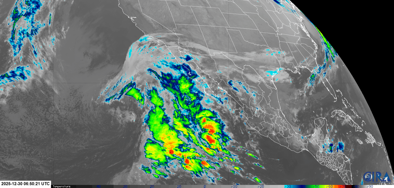
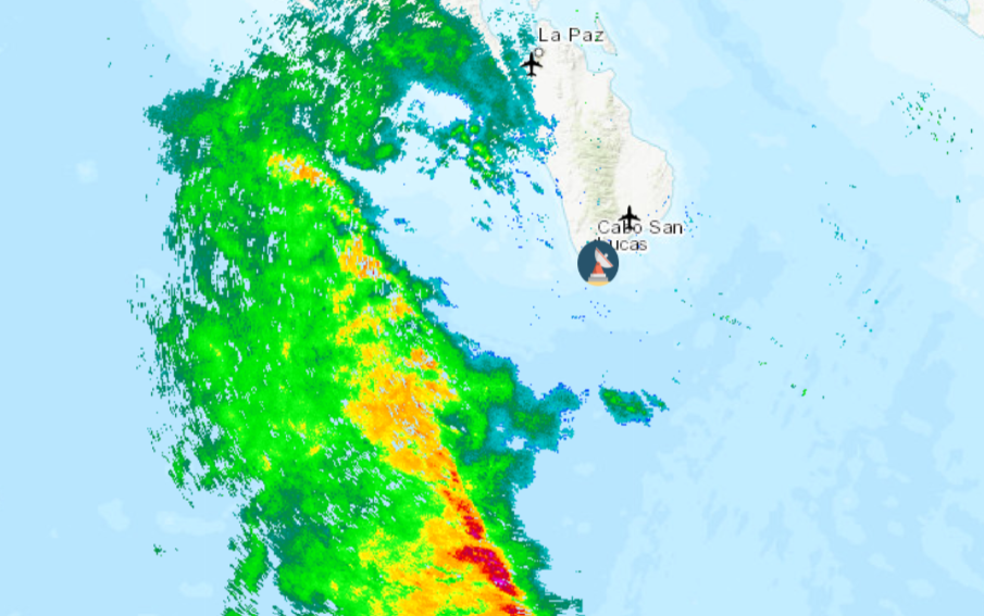
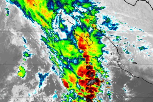
Wind – November 5, 2025

¡Buenos dias! Yesterday a few folks got a late afternoon bonus as the gauge at the campground showed winds of 12-14 mph from 3-5:30 pm. More of us should be getting into the game today as a late-evening pass by one of the ASCAT satellites measured solid 10 knot NW winds over the southern Sea of Cortez, and all of the latest model forecasts indicated similar background wind will continue today. A few thin, high clouds will stream overhead from time to time today, but enough filtered sunshine will likely make it through to give us an added thermal bump this afternoon. The surface pressure gradient is forecast to tighten tomorrow as Pacific high pressure continues to build into the Baja Peninsula and with sunny skies expected, we should see a windy afternoon. Models are in good agreement that the background flow will become marginal on Friday, with winds decreasing further on Saturday. Long-range model forecasts are in good agreement that a strong Canadian surface high pressure system will dive into the central U.S. on Sunday, with a ridge of high presssue extending westward into the Great Basin. This will likely give a renewed boost to our north flow, with sufficient north background flow likely lasting through next Tuesday.

  • Today…Mostly sunny. North wind 16-20 mph.
  • Thursday…Sunny. North wind 18-22 mph.
  • Friday…Sunny. North wind 12-14 mph.
  • Saturday…Sunny. Northeast wind 10-12 mph.
  • Sunday…Sunny. North wind 16-20 mph.
  • Monday…Sunny. North wind 16-18 mph.
  • Tuesday…Mostly sunny. North wind 16-18 mph.

Wind – November 4, 2025

¡Buenos dias! Yesterday was one of those days where northern beaches saw winds peaking around 16 mph, while southern beaches only hovered around 12 mph. It looks like light winds will be the rule at all area beaches today, as a late evening pass by the Oceansat satellite measured light and variable winds across the southern Sea of Cortez, and all of the most recent numerical model forecasts show light background flow continuing today. Surface high pressure over the eastern Pacific will strengthen and build eastward into the Baja Peninsula on Wednesday, and this will bring increasing NW flow to BCS. While model forecasts do show some west component to the background wind, sunny skies should help trigger a substantial local thermal to help pull the flow onshore. Winds may increase a bit on Thursday, and with only a few thin, high clouds expected, we should see another good thermal boost as well. Friday looks to be a marginal day at this point as models generally agree that the surface pressure gradient will weaken substantially over our area. Long-range model forecasts are in fairly good agreement that some north flow will return on Sunday and last at least through next Monday.

  • Today…Sunny. Northeast wind 10-12 mph.
  • Wednesday…Sunny. North wind 16-20 mph.
  • Thursday…Mostly sunny. North wind 18-22 mph.
  • Friday…Sunny. North wind 12-14 mph.
  • Saturday…Sunny. Northeast wind 10-12 mph.
  • Sunday…Sunny. North wind 16-20 mph.
  • Monday…Sunny. North wind 16-18 mph.

Nerd Note: As we move into November, we normally see temperatures begin to cool substantially (see graph of average temperatures in La Paz from Weatherspark). This year several weather stations in La Paz have continued to record high temperatures of 90-95F over the past couple of weeks, and even here in La Ventana yesterday’s high hovered around 90F. Long-range forecasts from the European Center for Medium Range Forecasting (ECMWF) are showing we will likely continue to see abnormally warm temperatures over the next week or so, however a pattern change in the middle levels of the atmosphere may bring us much cooler weather around November 15 (see graphs below).

Wind – November 3, 2025

¡Buenos dias! A couple of evening passes by the polar orbiting satellites missed BCS, so we’ll have to go solely with the latest batch of numerical model forecasts for today. Although there is some disagreement, a couple of the more reliable models show enough background flow will last through the afternoon, and with sunny skies expected, we should see a windy afternoon. Models continue to show that the surface pressure gradient will weaken substantially tomorrow, and it doesn’t look like we’ll have enough north flow remaining to fully trigger our local wind machine. Surface high pressure from the eastern Pacific is then forecast to build into the Baja Peninsula on Wednesday into Thursday, with solid NNW background flow returning to our region. While models show there may be a substantial west component to this pulse, sunny skies each day should trigger a substantial thermal which will pull the flow onshore. Most of the long-range model forecasts show a quick return to light background flow on Friday into Saturday, but we may see just enough north flow return by Sunday to give us a rideable day.

  • Today…Sunny. North wind 16-18 mph.
  • Tuesday…Sunny. Northeast wind 10-12 mph.
  • Wednesday…Sunny. North wind 16-20 mph.
  • Thursday…Sunny. North wind 18-22 mph.
  • Friday…Sunny. North wind 12-14 mph.
  • Saturday…Sunny. Northeast wind 10-12 mph.
  • Sunday…Sunny. North wind 16-18 mph.

Wind – November 2, 2025

¡Buenos dias! A pass by the Oceansat satellite around midnight confirmed that the next north pulse has arrived, with north winds of around 10 knots over the Sea of Cortez just east of Cerralvo, and winds up to 15 knots as far south as Loreto. Surface high pressure centered far to our northwest over the eastern Pacific was responsible for the surge in north flow, and all of the latest numerical model forecasts show solid north background flow will continue today. Infrared satellite loops early this morning indicated clear skies across our region, so we should get an added thermal boost this afternoon. Model forecasts are in good agreement that just enough north flow will last into Monday to give us a rideable day. The surface pressure gradient over BCS will weaken substantially on Tuesday, with only light winds expected here. Pacific high pressure is then forecast to strengthen and build into the southwestern U.S. on Wednesday into Thursday and bring a return of solid NNW background flow. Long-range model forecasts show the high weakening on Friday, but again there may be just enought north flow left to give us one more good day. At this point it looks like light winds will return again next Saturday.

  • Today…Sunny. North wind 18-22 mph.
  • Monday…Sunny. North wind 16-18 mph.
  • Tuesday…Sunny. Northeast wind 10-12 mph.
  • Wednesday…Sunny. North wind 16-20 mph.
  • Thursday…Sunny. North wind 18-22 mph.
  • Friday…Sunny. North wind 16-18 mph.
  • Saturday…Sunny. Northeast wind 10-12 mph.

Wind – November 1, 2025

¡Buenos dias! Light and variable winds were again detected over the southern Sea of Cortez by satellite passes last evening, and all model forecasts show light background flow will continue today. Model forecasts and in good agreement that the surface pressure pattern will tighten over BCS on Sunday, and with sunny skies expected, we will likely see a good thermal boost as well. The background flow will fall to marginal levels on Monday, and at this point it looks like it will be just below the level needed to fully activate our local wind machine. Tuesday will likely be a light wind day as the surface pressure gradient is forecast to be very weak, with only light onshore breezes expected. A return to windy afternoons is likely on Wenesday and Thursday as surface high pressure builds into BCS from the eastern Pacific. Long-range models disagree, but some are showing just enough background flow lasting into Friday to give us another windy afternoon.

  • Today…Sunny. Northeast wind 10-12 mph.
  • Sunday…Sunny. North wind 16-20 mph.
  • Monday…Sunny. North wind 14-16 mph.
  • Tuesday…Sunny. Northeast wind 10-12 mph.
  • Wednesday…Sunny. North wind 16-20 mph.
  • Thursday…Sunny. North wind 18-22 mph.
  • Friday…Sunny. North wind 16-18 mph.

Nerd Note: The U.S. Climate Prediction Center (part of NOAA) just issued its outlook for temperature and precipitation for November, and it shows a continuation of warm and dry conditions for the interior west of the U.S. For us this likely means above normal temperatues and fewer strong nortes as a ridge of high pressure in the middle levels of the atmosphere over the interior west of the U.S. will keep strong surface high pressure systems from descending into the interior west from Canada. The image below shows typical conditions for a developing norte, with a strong mid-level ridge of high pressure along the west coast and strong mid-level trough inland (B). This usually leads to a strong surface high over the interior west of the U.S., with a tight surface pressure gradient over BCS as the surface high builds into the 4-corners region (A). The Climate Prediction Center forecast for November (derived from their text discussion) indicates the opposite mid-level pattern, with a trough of low pressure off the west coast and a ridge of high pressure inland over the interior west.

Wind – October 31, 2025

¡Buenos dias! Light and variable winds were detected over the southern Sea of Cortez by satellite passes last evening, and all of the most recent model forecasts show light background flow will continue today. North flow will increase a bit on Saturday, but at this point it looks like it’ll fall just short of what is usually needed to trigger our local wind machine. Models are in good agreement that the surface pressure gradient will tighten on Sunday, and with full sunshine expected, we will likely see a windy afternoon. Monday will be another on the fence day, with marginal north background flow. At this point Tuesday looks to be a down day, with model forecasts showing a weak surface pressure gradient over BCS. Long-range forecasts are in good agreement that Pacific high pressure will begin to build into our region Wednesday into Thursday, with NNW bacground flow increasing.

  • Today…Sunny. East wind 8-10 mph.
  • Saturday…Sunny. Northeast wind 10-12 mph.
  • Sunday…Sunny. North wind 16-20 mph.
  • Monday…Sunny. North wind 14-16 mph.
  • Tuesday…Sunny. Northeast wind 10-12 mph.
  • Wednesday…Sunny. North wind 16-20 mph.
  • Thursday…Sunny. North wind 18-22 mph.

Wind – October 30, 2025

¡Buenos dias! An evening pass by one of the polar-orbiting satellites measured 5 knot NW winds over the southern Sea of Cortez, and all of the most recent model forecasts continue to show a very weak background flow for today, with only a summer-like onshore breeze developing this afternoon. Similar conditions are expected on Friday, and it now appears that although we should see a return of north flow on Saturday, it will likely be too weak to fully energize our local wind machine. Models are in good agreement that we will see the surface pressure gradient tighten on Sunday, and with full sunshine expected we should see a windy afternoon. At this point the long-range model forecasts look marginal at best for Monday and Tuesday, as the surface pressure gradient again becomes weak, but a new pulse of north flow could arrive as early as Wendesday.

  • Today…Sunny. East wind 8-10 mph.
  • Friday…Sunny. East wind 8-10 mph.
  • Saturday…Sunny. Northeast wind 10-12 mph.
  • Sunday…Sunny. North wind 16-20 mph.
  • Monday…Sunny. Northeast wind 10-12 mph.
  • Tuesday…Sunny. Northeast wind 10-12 mph.
  • Wednesday…Sunny. North wind 16-20 mph.

Wind – October 29, 2025

¡Buenos dias! The wind gauge at the campground showed an unusual profile with two peaks yesterday…one from around 2-3:30, then another late one from around 4:30-5:30 (see graph below). Satellite passes yesterday afternoon indicated that the second peak was a new surge of north background flow, however it arrived a bit too late to fully team up with our local thermal, so winds only peaked at around 18 mph instead of the 20-24 mph I expected. A satellite pass last evening measured 10 knot NW winds over much of the southern Sea of Cortez, and forecast models show similar backgroud flow will continue today. With another sunny day ahead we will likely see a substantial thermal boost, and with north background flow already in place, we should see a more normal wind profile, with winds increasing by around midday. A sprawling ridge of high pressure covering much of the western U.S. this morning will weaken quickly tonight, leaving a weak surface pressure gradient with only light onshore flow expected Thursday and Friday. Forecast models are in fairly good agreement that Canadian high pressure will work its way southeastward and bring a new pulse of north flow to BCS…possibly as early as Saturday afternoon. Sunday looks to be the windiest day of the upcoming weekend, and long-range model forecast show just enough north background flow may last into Monday. At this point it looks like Tuesday will be another light wind day as the surface pressure gradient over our region becomes very weak.

  • Today…Sunny. North wind 16-20 mph.
  • Thursday…Sunny. East wind 8-10 mph.
  • Friday…Sunny. East wind 8-10 mph.
  • Saturday…Sunny. North wind 16-18 mph.
  • Sunday…Sunny. North wind 16-20 mph.
  • Monday…Sunny. North wind 16-18 mph.
  • Tuesday…Sunny. East wind 8-10 mph.

Wind – October 28, 2025

¡Buenos dias! A satellite pass measured northwest winds of 10 knots over the southern Sea of Cortez around midnight, but farther north near Santa Rosalia, a new surge of north winds was detected. The latest numerical model forecasts show this new surge of north flow making its way steadily southward today and likely reaching us by mid-late afternoon. Infrared satellite loops show clear skies across our region, and while we will likely see rideable winds with an early afternoon thermal bump, it may be a relatively late show as the new surge of north background flow arrives. Model forecasts are once again in excellent agreement that surface high pressure centered over Idaho this morning will build southeastward on Wednesday, with solid north background flow continuing over BCS. We’ll get a couple of rest days on Thursday and Friday as the surface pressure gradient becomes weak, with only light onshore breezes expected. Long-range model forecasts show surface high pressure over British Columbia will build into the interior west of the U.S. on Saturday, with a fresh pulse of north flow making its way down the Sea of Cortez. Solid north flow will likely continue at least through Sunday and possibly into Monday.

  • Today…Sunny. North wind building to 20-24 mph.
  • Wednesday…Sunny. North wind 16-20 mph.
  • Thursday…Sunny. East wind 8-10 mph.
  • Friday…Sunny. East wind 8-10 mph.
  • Saturday…Sunny. North wind 16-18 mph.
  • Sunday…Sunny. North wind 16-20 mph.
  • Monday…Sunny. North wind 16-18 mph.

Wind – October 27, 2025

¡Buenos dias! A pass by one of the polar orbiting satellites around midnight showed yesterday’s strong north background flow had decreased overnight, with 10 knot NW winds detected over the southern Sea of Cortez. Although the background flow will be substantially less today, several model forecasts do show just enough remaining to help jump-start our local wind machine. A band of high clouds over us this morning will quickly move eastward and leave full sunshine by midday, so we’ll also get a substantial thermal boost this afternoon. Surface high pressure centered over the Pacific Northwest of the U.S. today will build southeastward on Tuesday, with the surface pressure gradient tightening over BCS and north flow increasing. Some thin, high clouds may stream over from time to time, but enough filtered sunshine should make it through to give us a good thermal boost as well. The surface high will then move rapidly southeastward into western Texas on Wednesday and maintain a solid north background flow over our region. Model forecasts are in excellent agreement that the background flow will then rapidly weaken on Thursday, with summerlike onshore breezes expected both Thursday and Friday. A new surface high is then forecast to build into the 4-corners region of the U.S. just in time for the weekend, with solid north background flow returning on Saturday and continuing through at least Sunday.

  • Today…Some morning high clouds, then becoming sunny. North wind 16-18 mph.
  • Tuesday…Mostly sunny. North wind 20-24 mph.
  • Wednesday…Sunny. North wind 16-20 mph.
  • Thursday…Sunny. East wind 8-10 mph.
  • Friday…Sunny. East wind 8-10 mph.
  • Saturday…Sunny. North wind 16-18 mph.
  • Sunday…Sunny. North wind 16-20 mph.

Nerd Note: A potentially catastrophic event is unfolding for the island nation of Jamaica, as a hurricane hunter aircraft early this morning showed hurricane Mellisa has become a category 5 storm with sustained winds of 160 mph. The storm is expected to make landfall on the southernwestern coast of Jamaica tonight. Here is a visible satellite image from just after sunrise showing the dark, clear eye, and sunlight reflecting off the western eyewall showing the spectacular stadium effect as the eyewall flares outward with height.